Category:Roches-Douvres Lighthouse
Jump to navigation
Jump to search
|
This building is classé au titre des monuments historiques de la France. It is indexed in the base Mérimée, a database of architectural heritage maintained by the French Ministry of Culture, under the references PA22000050
|
| Object location | | View all coordinates using: OpenStreetMap |
|---|
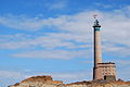
lighthouse in Côtes-d'Armor, France  Roches-Douvres Light, 2009 | |||||
| Upload media | |||||
| Instance of | |||||
|---|---|---|---|---|---|
| Made from material | |||||
| Location | Île-de-Bréhat, Côtes-d'Armor, Brittany, Q88521114, Metropolitan France, France | ||||
| Located in or next to body of water | |||||
| Architect | |||||
| Operator | |||||
| Heritage designation |
| ||||
| Service entry |
| ||||
| Inception |
| ||||
| Significant event |
| ||||
| Height |
| ||||
| Elevation above sea level |
| ||||
| Replaces | |||||
 | |||||
Subcategories
This category has only the following subcategory.
R
Media in category "Roches-Douvres Lighthouse"
The following 5 files are in this category, out of 5 total.
-
 Jouas-Poutrel François Mont Saint-Michel.JPG 3,264 × 2,448; 1.92 MB
-
 La Horaine bouteille.JPG 3,264 × 2,448; 2.43 MB
-
 Roches Douvres-2.jpg 1,754 × 2,592; 916 KB
-
 Roches Douvres.jpg 3,872 × 2,592; 2.02 MB
-
 Roches-Douvres Lighthouse.jpg 1,255 × 909; 804 KB


Categories:
- Lighthouses on wave-washed rocks
- Lighthouses in France by name
- 19th-century lighthouses in Côtes-d'Armor
- Lighthouses built in 1954
- 20th-century lighthouses in Côtes-d'Armor
- Lighthouses by height, 61 to 70 meters
- Stone lighthouses in France
- Monuments historiques in Côtes-d'Armor (lighthouses)
- Unpainted lighthouses in France
- Lighthouses by range, 20 to 24 nm
- Landfall lights
- Lighthouse equipment by Barbier, Bénard et Turenne
- Henry Auffret
- Joël Hardion
- Monuments historiques in Île-de-Bréhat