Category:Roads in New Zealand
Jump to navigation
Jump to search
English: Primarily for images of non-urban roads. See also Category:Streets in New Zealand
Wikimedia category | |||||
| Upload media | |||||
| Instance of | |||||
|---|---|---|---|---|---|
| Category combines topics | |||||
 | |||||
Subcategories
This category has the following 20 subcategories, out of 20 total.
C
- Cracks (road) in New Zealand (8 F)
E
F
- Forest roads in New Zealand (5 F)
G
M
N
R
S
T
- Thompsons Track (1 F)
V
Media in category "Roads in New Zealand"
The following 92 files are in this category, out of 92 total.
-
 2022-06-03 Whataroa New Zealand 1.jpg 4,000 × 2,250; 3.67 MB
-
 Aerial-Ohope Bch.JPG 3,072 × 2,304; 2.69 MB
-
 Akatarawa Road - panoramio (1).jpg 1,536 × 2,048; 3.23 MB
-
 Along the River Road by Jacqui McGowan.jpg 3,872 × 2,592; 3.19 MB
-
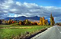 Autumn in Otago, New Zealand.jpg 2,359 × 1,504; 588 KB
-
 Barnes Road.jpg 4,032 × 2,268; 4.1 MB
-
 Barrytown.jpg 800 × 600; 117 KB
-
 Bridge Over Creek West Of Near Albany.jpg 1,600 × 1,200; 1.05 MB
-
 Cobb Dam River Rd, Kahurangi National Park, New Zealand.jpg 5,472 × 3,648; 18.22 MB
-
 Cruise through New Zealand (3423393269).jpg 3,054 × 2,036; 818 KB
-
 Cycle Lane On Waiheke Island Road.jpg 1,599 × 1,200; 1.17 MB
-
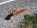 Dead possum.jpg 2,272 × 1,704; 2.19 MB
-
 Driving Route 9, NZ (52336050095).jpg 6,044 × 4,030; 1.22 MB
-
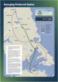 Emerging Preferred Option for Second Waitematā Harbour Crossing (August 2023).png 2,425 × 3,412; 2.6 MB
-
 Eroded Road at Whatarangi Bluff, Palliser Bay-2.jpg 3,872 × 2,592; 2.31 MB
-
 Eroded Road at Whatarangi Bluff, Palliser Bay.jpg 3,872 × 2,592; 2.37 MB
-
 Farm road in Marlborough.jpg 3,694 × 2,503; 8.86 MB
-
 Ferry Wharf Eastern End Of Waiheke Island.jpg 1,600 × 1,200; 304 KB
-
 Fire Station Building Near Entry To Twizel.jpg 1,600 × 800; 218 KB
-
 Flowers by the Road, New Zealand (3424195660).jpg 2,973 × 1,982; 1.31 MB
-
 FMIB 35284 Rangitata River at the Traffic Bridge.jpeg 826 × 563; 107 KB
-
 Fonterra Facility Near Hamilton.jpg 1,800 × 1,000; 982 KB
-
 Glacier Hwy, NZ (52293430446).jpg 7,763 × 5,176; 1.1 MB
-
 Gorge.jpg 546 × 409; 74 KB
-
 Gorge1.jpg 534 × 400; 24 KB
-
 Goulstone road.jpg 270 × 424; 114 KB
-
 Henley.jpg 1,397 × 1,000; 896 KB
-
 Hicks Bay, East Coast, New Zealand, 13th. Dec. 2010 - Flickr - PhillipC.jpg 3,825 × 2,384; 2.03 MB
-
 Hurunui Coastal Track in Manuka Bay, Hurunui District, Canterbury, New Zealand 02.jpg 5,472 × 3,648; 16.04 MB
-
 Kiwi signpost.jpg 595 × 483; 103 KB
-
 La ruta de camino a la cuidad.jpg 960 × 1,280; 98 KB
-
 Lake Alexandrina.jpg 1,993 × 1,309; 405 KB
-
 Lake Brunner Road 01.jpg 4,237 × 2,825; 8.41 MB
-
 Lake Brunner Road 02.jpg 3,721 × 2,560; 7.27 MB
-
 Lake Brunner Road 03.jpg 3,480 × 2,320; 6.19 MB
-
 Lake Taupo Neuseeland Nordinsel.jpg 1,514 × 992; 1.05 MB
-
 Lake Wakatipu, New Zealand (7187558802).jpg 4,608 × 3,072; 3.39 MB
-
 Lonely drive (2054105490).jpg 3,737 × 2,502; 3.15 MB
-
 Looking East Along The Clutha River.jpg 1,600 × 1,200; 429 KB
-

-
 Manapouri Road.jpg 1,280 × 853; 345 KB
-
 Maratai.jpg 1,600 × 1,200; 743 KB
-
 Melling Branch 03.JPG 2,048 × 1,536; 1.42 MB
-
 Morrinsville.JPG 640 × 480; 89 KB
-
 Mount Pohaturoa, Atiamuri.jpg 1,536 × 2,048; 2.53 MB
-
 Mpr Corner.JPG 1,973 × 1,318; 532 KB
-
 Mt Tongariro ^ Ngaruhoe from National Park - Flickr - 111 Emergency.jpg 1,280 × 626; 134 KB
-
 Neuseeland westlich von Geraldine.jpg 800 × 600; 215 KB
-
 No Entry, near Kauaeranga Visitor Center.jpg 3,072 × 2,048; 10.09 MB
-
 North Avon Road, Richmond, Christchurch, New Zealand 05.jpg 5,472 × 3,648; 15.39 MB
-
 North Avon Road, Richmond, Christchurch, New Zealand.jpg 5,472 × 3,356; 13.03 MB
-
 NZ-Te Waewae B.png 440 × 497; 33 KB
-
 Nzroadneartekapo.JPG 3,072 × 2,304; 3.41 MB
-
 Ohakune Mountain Road, Mount Ruapehu, through snow-covered bush.jpg 1,024 × 768; 287 KB
-
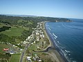
 Ohope overview.JPG 3,069 × 2,160; 2.77 MB
-
 Otago Harbour Walls1.JPG 2,048 × 1,536; 2.9 MB
-
 Otira gorge, west coast road.jpg 929 × 616; 139 KB
-
 Overlander - Flickr - Teacher Traveler (2).jpg 1,024 × 687; 513 KB
-
 PointDorset.jpg 2,048 × 1,536; 1.71 MB
-
 Porirua Harbour harbour road view 2.jpg 4,000 × 3,000; 3.32 MB
-
 Porirua Harbour road view.jpg 4,000 × 3,000; 3.35 MB
-
 PortobelloNZ.jpg 1,627 × 717; 396 KB
-
 Purau Avenue, Purau, Canterbury, New Zealand 11.jpg 5,472 × 3,648; 15.91 MB
-
 Queenstown-Lakes 15.jpg 4,160 × 2,760; 9.09 MB
-
 Renwick New Zealand.jpg 1,024 × 768; 155 KB
-
 Road by the beach in Little Akaloa, Canterbury, New Zealand.jpg 5,472 × 3,648; 16.96 MB
-
 Road in Castle Hill Village, Canterbury, New Zealand 18.jpg 5,472 × 3,648; 13.49 MB
-
 Road to Milford Sound (5862653045).jpg 3,872 × 2,379; 1.45 MB
-
 Road to Milford Sound (5862653439).jpg 3,872 × 2,363; 850 KB
-
 Road to Mountains.jpg 4,928 × 3,264; 10.91 MB
-
 Rural New Zealand-3771.jpg 675 × 900; 553 KB
-
 Rural Road Near Kinloch.jpg 1,600 × 1,200; 1.33 MB
-
 School bus stop, Lake Hāwea (town), New Zealand.jpg 5,472 × 3,648; 16.99 MB
-
 Sheep traffic jam near Patearoa - Otago.jpg 3,872 × 2,592; 4.54 MB
-
 Steam Pipelines Near Taupo.jpg 1,600 × 1,200; 1.12 MB
-
 Sturrocks Road looking East.jpg 4,032 × 2,268; 2.35 MB
-
 Sturrocks Road looking West.jpg 4,032 × 2,268; 2.46 MB
-
 Tennyson Inlet Road goes around a tree 040.JPG 2,448 × 3,264; 3.58 MB
-
 The long road home. (22737160409).jpg 3,656 × 2,507; 5.76 MB
-
 The road to Mt Cook. (Unsplash).jpg 5,184 × 3,456; 1.45 MB
-
 Transmission Gully Motorway Wainui Saddle summit southbound.jpg 4,800 × 3,200; 2.53 MB
-
 Trunk fools.jpg 400 × 280; 25 KB
-
 Upper Moutere North Nov 2007.jpg 1,944 × 2,592; 443 KB
-
 Waihaha Hill Coming Up Lake Taupo.jpg 1,600 × 1,200; 202 KB
-
-
 Wairoa Road N.Z. (8953022437).jpg 4,267 × 6,171; 1.09 MB
-
 Waitangi, Chatham Islands.jpg 1,200 × 397; 338 KB
-
 Westport Holcim Cement Plant Skyline.jpg 1,800 × 1,200; 1.25 MB
-
 Whangaparaoa Peninsula Road I.jpg 2,000 × 880; 1.04 MB
-
 Whangaparaoa Peninsula Road II.jpg 2,000 × 880; 867 KB
-
 Wilkin Road, Otago, New Zealand.jpg 5,472 × 3,648; 17.49 MB
-
 Winter Road (5830416376).jpg 900 × 675; 304 KB


.jpg)


.jpg)


.jpg)
.png)


.jpg)


.jpg)


.jpg)
.jpg)


.jpg)


.jpg)
.jpg)


,_New_Zealand.jpg)


.jpg)
.jpg)


.jpg)


.jpg)