Category:River Dee, England
Jump to navigation
Jump to search

Subcategories
This category has the following 4 subcategories, out of 4 total.
Media in category "River Dee, England"
The following 104 files are in this category, out of 104 total.
-
 A Channel in the Dee Marshes - geograph.org.uk - 196782.jpg 640 × 480; 61 KB
-

-
 Across the sands of Dee - geograph.org.uk - 825518.jpg 640 × 457; 250 KB
-
 Afon Dyfrdwy in the evening sunshine - geograph.org.uk - 593653.jpg 640 × 480; 73 KB
-
 Bend in the River Dee near Crewe Hill - geograph.org.uk - 350723.jpg 640 × 480; 131 KB
-
 Benkid77 Dee estuary, Parkgate 2 240709.JPG 3,648 × 2,736; 3.65 MB
-
 Benkid77 Dee estuary, Parkgate 3 240709.JPG 3,648 × 2,736; 3.66 MB
-
 Benkid77 Dee estuary, Parkgate 4 240709.JPG 3,648 × 2,736; 3.64 MB
-
 Benkid77 Flint from Thurstaston 200709.JPG 2,240 × 1,680; 930 KB
-
 Benkid77 Little Eye and Point of Ayr 200709.JPG 2,240 × 1,680; 802 KB
-
 Benkid77 Small boats, River Dee 200709.JPG 2,240 × 1,680; 872 KB
-
 Black clouds over Caldy Blacks - geograph.org.uk - 1240394.jpg 640 × 480; 144 KB
-
 Boats on the bank of the River Dee - geograph.org.uk - 409353.jpg 640 × 480; 52 KB
-
 Caldy Blacks, shore and Dee - geograph.org.uk - 645587.jpg 640 × 480; 59 KB
-
 Caldy Hill - geograph.org.uk - 36670.jpg 640 × 480; 46 KB
-
 Car in the River Dee - geograph.org.uk - 387698.jpg 600 × 480; 141 KB
-
 Christmas Past by the River Dee - geograph.org.uk - 379444.jpg 640 × 480; 61 KB
-
 Cliff edge and the Dee estuary - geograph.org.uk - 1737027.jpg 800 × 530; 183 KB
-
 Crook of Dee - geograph.org.uk - 110794.jpg 640 × 480; 116 KB
-
 Curzon Park Chester.JPG 2,592 × 1,944; 2.57 MB
-
 Dee Estuary from Lime Wharf - geograph.org.uk - 218687.jpg 640 × 480; 100 KB
-
 Dee estuary wildlife cruise - geograph.org.uk - 220465.jpg 640 × 480; 53 KB
-
 Dee estuary.jpg 640 × 480; 122 KB
-
 Dee estuary2.jpg 640 × 480; 67 KB
-
 Dee Marshes - geograph.org.uk - 146855.jpg 640 × 480; 163 KB
-
 Dee saltmarsh, Gayton - geograph.org.uk - 69729.jpg 640 × 480; 61 KB
-
 Drainage Ditch and the River Dee - geograph.org.uk - 382086.jpg 640 × 480; 125 KB
-
 East Hoyle Bank-by-Peter-Craine.jpg 640 × 480; 72 KB
-
 Eccleston Ferry House 1.jpg 2,592 × 1,944; 1.09 MB
-
 Eccleston Ferry River Dee - geograph.org.uk - 79194.jpg 640 × 480; 88 KB
-
 Farndon Bridge and Sandstone Cliff - geograph.org.uk - 197139.jpg 640 × 480; 118 KB
-
 Fence Line by the River Dee - geograph.org.uk - 380092.jpg 640 × 480; 167 KB
-
 Flint from Burton.JPG 3,648 × 2,736; 3.68 MB
-
-
 Grey seals on West Hoyle Bank - geograph.org.uk - 220438.jpg 640 × 480; 87 KB
-
 High Tide at Saltney Ferry - geograph.org.uk - 278815.jpg 640 × 428; 36 KB
-

-
 Liverpool Bay.png 1,278 × 947; 1.84 MB
-
 Looking across the River Dee from West Kirby - DSCF1843.JPG 4,000 × 3,000; 2.84 MB
-
 Looking across to Flintshire from The Parade, Parkgate.JPG 4,320 × 3,240; 3.89 MB
-
 Looking into the sun over Dawpool Bank - geograph.org.uk - 48960.jpg 640 × 360; 92 KB
-
 Looking over Dawpool Bank - geograph.org.uk - 48973.jpg 640 × 359; 54 KB
-
 Looking towards the Moel-y-Parc transmitter from West Kirby - DSCF1842.JPG 4,000 × 3,000; 2.77 MB
-
 Looking towards the Moel-y-Parc transmitter from West Kirby - DSCF1848.JPG 4,000 × 3,000; 2.79 MB
-
 Looking towards the Point of Ayr lighthouse, Talacre from West Kirby - DSCF1856.JPG 4,000 × 3,000; 2.84 MB
-
 Low tide on the River Dee-Afon Dyfrdwy - geograph.org.uk - 686767.jpg 640 × 480; 139 KB
-
 Near the Crook of Dee - geograph.org.uk - 63318.jpg 640 × 480; 220 KB
-
 Pathfinder in the River Dee - geograph.org.uk - 404667.jpg 640 × 480; 140 KB
-
 Pathfinder in the River Dee - geograph.org.uk - 405619.jpg 640 × 480; 136 KB
-

-
 Pill Box on Saltney Quay - geograph.org.uk - 282280.jpg 640 × 480; 185 KB
-
 Pillbox on Saltney Quay - geograph.org.uk - 340610.jpg 640 × 480; 148 KB
-
 Pillbox on Saltney Quay - geograph.org.uk - 388755.jpg 640 × 480; 157 KB
-
 Pond in the silted River Dee - geograph.org.uk - 1500558.jpg 640 × 480; 67 KB
-
 Reed beds on the river Dee at Neston - geograph.org.uk - 1495876.jpg 640 × 480; 131 KB
-
 River Dee between Holt and Farndon.jpg 640 × 480; 80 KB
-
 River Dee Estuary - geograph.org.uk - 640162.jpg 640 × 420; 32 KB
-
 River Dee-Afon Dyfrdwy - geograph.org.uk - 281713.jpg 640 × 480; 189 KB
-
 River Dee-Afon Dyfrdwy and cycleway - geograph.org.uk - 686773.jpg 640 × 480; 77 KB
-
 Sailing boats on Gayton Channel - geograph.org.uk - 69691.jpg 640 × 480; 58 KB
-
 Saltmarsh on the river Dee - geograph.org.uk - 69708.jpg 640 × 480; 61 KB
-

-

-
 The Banks of the River Dee - geograph.org.uk - 350716.jpg 640 × 480; 211 KB
-

-
 The Dee marshes at Little Neston (1).JPG 4,320 × 3,240; 4.17 MB
-
 The Dee marshes at Little Neston (2).JPG 4,320 × 3,240; 4.03 MB
-
 The Dee marshes at Parkgate (1).JPG 4,320 × 3,240; 4.4 MB
-
 The Dee marshes at Parkgate (2).JPG 4,320 × 3,240; 3.17 MB
-
 The Dee marshes at Parkgate (3).JPG 4,320 × 3,240; 2.96 MB
-
 The Dee marshes at Parkgate (4).JPG 4,320 × 3,240; 3.62 MB
-
 The Dee marshes at Parkgate (5).JPG 4,320 × 3,240; 3.76 MB
-

-
 The Peaceful River Dee - geograph.org.uk - 350710.jpg 640 × 480; 190 KB
-
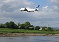 The River Dee and the Airbus A380 - geograph.org.uk - 290112.jpg 640 × 457; 108 KB
-
 The River Dee at Aldford - geograph.org.uk - 2440769.jpg 3,888 × 2,592; 6.1 MB
-
 The River Dee near Aldford - geograph.org.uk - 2440807.jpg 7,888 × 5,260; 5.24 MB
-
 The River Dee near Aldford - geograph.org.uk - 2440823.jpg 3,888 × 2,592; 6.25 MB
-
 The River Dee near Aldford - geograph.org.uk - 2440836.jpg 5,888 × 3,925; 3.63 MB
-
 The River Dee near Aldford - geograph.org.uk - 2441106.jpg 4,888 × 3,259; 4.36 MB
-
 The River Dee near Crewe Hill - geograph.org.uk - 329201.jpg 640 × 480; 78 KB
-
 The River Dee near Holt Castle - geograph.org.uk - 980945.jpg 640 × 480; 70 KB
-
 The River Dee near Sandycroft - geograph.org.uk - 382174.jpg 640 × 480; 122 KB
-
 The River Dee-Afon Dyfrdwy - geograph.org.uk - 281219.jpg 640 × 480; 178 KB
-
 The Saltney Ferry steps and tidal bore - geograph.org.uk - 275848.jpg 640 × 480; 144 KB
-
 The tide coming in at Parkgate, Cheshire 2002-03-30.JPG 1,280 × 1,024; 296 KB
-
 Thurstaston beach - IMG 0857.JPG 4,320 × 3,240; 3.03 MB
-
 Thurstaston beach - IMG 0859.JPG 4,320 × 3,240; 3 MB
-
 Thurstaston beach - IMG 0860.JPG 3,240 × 4,320; 4.06 MB
-
 Tinker's Dell Steps - geograph.org.uk - 1730124.jpg 427 × 640; 196 KB
-
 Trees on Banks of The Dee - geograph.org.uk - 2399200.jpg 788 × 1,123; 799 KB
-
 View of Wales from West Kirby Marine Lake - DSCF1846.JPG 4,000 × 3,000; 2.87 MB
-
-
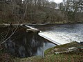
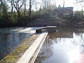 Weir on the river Dee - geograph.org.uk - 637872.jpg 640 × 480; 100 KB
-
 West Kirby and the River Dee - IMG 1096.JPG 4,320 × 3,240; 3.92 MB
-
 Wirral peninsula satellite.png 400 × 400; 299 KB
-
 Woodland on the Banks of the River Dee - geograph.org.uk - 350380.jpg 480 × 640; 218 KB
-
-
 Dead tree by the River Dee-Afon Dyfrdwy - geograph.org.uk - 687069.jpg 480 × 640; 262 KB
-

-
 Sandbank on the River Dee - geograph.org.uk - 350668.jpg 640 × 480; 236 KB
-

-
 The River Dee-Afon Dyfrdwy - geograph.org.uk - 282259.jpg 640 × 457; 70 KB
-


.JPG)
.JPG)
.JPG)
.JPG)
.JPG)
.JPG)
.JPG)


