Category:Richards Covered Bridge
Jump to navigation
Jump to search
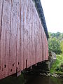
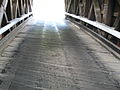
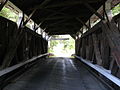
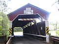
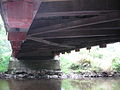
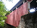
English: Richards Covered Bridge built in 1852 over the South Branch of Roaring Creek between Cleveland Township in Columbia County, Pennsylvania and Ralpho Township in Northumberland County, Pennsylvania, in the United States
|
This is a category about a place or building that is listed on the National Register of Historic Places in the United States of America. Its reference number is 79002308. |
| Object location | | View all coordinates using: OpenStreetMap |
|---|
 | |||||
| Upload media | |||||
| Instance of | |||||
|---|---|---|---|---|---|
| Location | Pennsylvania | ||||
| Crosses | |||||
| Heritage designation |
| ||||
 | |||||
Media in category "Richards Covered Bridge"
The following 13 files are in this category, out of 13 total.
-
 Richards Covered Bridge 1.JPG 3,648 × 2,736; 3.15 MB
-
 Richards Covered Bridge 10.JPG 2,736 × 3,648; 3.12 MB
-
 Richards Covered Bridge 11.JPG 3,648 × 2,736; 2.67 MB
-
 Richards Covered Bridge 12.JPG 2,736 × 3,648; 2 MB
-
 Richards Covered Bridge 13.JPG 3,648 × 2,736; 2.2 MB
-
 Richards Covered Bridge 2.JPG 3,648 × 2,736; 4.01 MB
-
 Richards Covered Bridge 3.jpg 7,619 × 2,982; 4.95 MB
-
 Richards Covered Bridge 4.jpg 3,980 × 2,949; 2.12 MB
-
 Richards Covered Bridge 5.JPG 3,648 × 2,736; 2.19 MB
-
 Richards Covered Bridge 6.JPG 3,648 × 2,736; 2.36 MB
-
 Richards Covered Bridge 7.JPG 3,648 × 2,736; 2.4 MB
-
 Richards Covered Bridge 8.JPG 3,648 × 2,736; 3.11 MB
-
 Richards Covered Bridge 9.JPG 3,648 × 2,736; 3.28 MB


Categories:
- National Register of Historic Places in Columbia County, Pennsylvania
- National Register of Historic Places in Northumberland County, Pennsylvania
- Covered bridges in Pennsylvania
- Bridges in Columbia County, Pennsylvania
- Bridges in Northumberland County, Pennsylvania
- Bridges on the National Register of Historic Places in Pennsylvania
- South Branch Roaring Creek
- Covered bridges on the National Register of Historic Places in Pennsylvania