Category:Rice Lane cemetery, Walton
Jump to navigation
Jump to search
| Object location | | View all coordinates using: OpenStreetMap |
|---|
cemetery  | |||||
| Upload media | |||||
| Instance of | |||||
|---|---|---|---|---|---|
| Location | |||||
| Inception |
| ||||
 | |||||
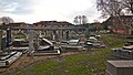
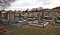
Jewish burial ground in use from 1896 until 1983. On Hazeldale Road, off Rice Lane.
Media in category "Rice Lane cemetery, Walton"
The following 4 files are in this category, out of 4 total.
-
 Rice Lane Jewish Cemetery 1.jpg 4,817 × 2,893; 18.72 MB
-
 Rice Lane Jewish Cemetery 2.jpg 5,139 × 3,075; 19.41 MB
-
 Rice Lane Jewish Cemetery 3.jpg 5,145 × 2,902; 22.66 MB
-
 Rice Lane Jewish Cemetery 4.jpg 4,992 × 2,927; 21.56 MB


