Category:Riburg Bürkli
Jump to navigation
Jump to search
| Object location | | View all coordinates using: OpenStreetMap |
|---|
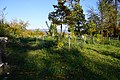
archaeological site in Möhlin in the canton of Aargau, Switzerland   | |||||
| Upload media | |||||
| Instance of |
| ||||
|---|---|---|---|---|---|
| Part of | |||||
| Location | Möhlin, Rheinfelden District, Aargau, Switzerland | ||||
| Street address |
| ||||
| Heritage designation | |||||
| Structure replaces |
| ||||
 | |||||
Media in category "Riburg Bürkli"
The following 12 files are in this category, out of 12 total.
-
 BS Burgus auf dem Bürkli (CH).png 1,325 × 857; 116 KB
-
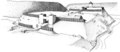
 Darstellung der Rhyburg Bürkli CH, 1871 F. Keller.png 1,200 × 1,031; 1.2 MB
-
 KAAG Mol-014-5 InfoT illu.tif 13,500 × 5,850; 9.45 MB
-
 Moehlin-Ryburg-1.jpg 1,200 × 800; 1.49 MB
-
 Moehlin-Ryburg-2.jpg 1,200 × 800; 1.47 MB
-
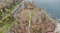 Möhlin Bürkli DJI 0595.jpg 4,056 × 2,280; 5.43 MB
-
 Riburg-Bürkli 1.JPG 6,000 × 4,000; 8.6 MB
-
 Riburg-Bürkli 2.JPG 6,000 × 4,000; 8.38 MB
-
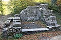 Riburg-Bürkli 3.JPG 6,000 × 4,000; 8.15 MB
-
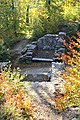 Riburg-Bürkli 4.JPG 4,000 × 6,000; 8.49 MB
-
 Riburg-Bürkli 5.JPG 6,000 × 4,000; 10.69 MB
-
 Wehranlage Bürli in Möhlin-Riburg - Info.jpg 7,952 × 5,304; 9.11 MB
.png)


