Category:Rauhhorn
Jump to navigation
Jump to search
mountain in the Allgäu Alps at the border Tyrol / Bavaria  | |||||
| Upload media | |||||
| Instance of | |||||
|---|---|---|---|---|---|
| Made from material | |||||
| Location |
| ||||
| Mountain range | |||||
| Topographic prominence |
| ||||
| Topographic isolation |
| ||||
| Elevation above sea level |
| ||||
 | |||||
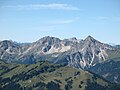
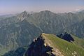
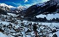
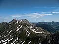
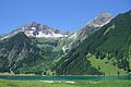
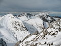
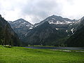
Deutsch: Das Rauhhorn ist ein 2240 Meter hoher Berg in den Allgäuer Alpen, über den die Grenze zwischen Deutschland (Bayern) und Österreich (Tirol) verläuft.
English: The Rauhhorn (2240 m) is a mountain in the Allgäu Alps, situated on the border between Germany (Bavaria) and Austria (Tyrol).
Media in category "Rauhhorn"
The following 32 files are in this category, out of 32 total.
-
 - Rauhhorn 2240 Hm.jpg 3,264 × 2,448; 1.66 MB
-
 Berge um das Rauhhorn im Tannheimer Tal - panoramio.jpg 3,872 × 1,578; 429 KB
-
 Blick vom Litnisschrofen nach Westen.JPG 3,264 × 2,448; 7.64 MB
-
 Gaishorn (2247m) & Rauhorn (2240m).JPG 1,920 × 1,080; 1.17 MB
-
 Gaishorn Rauhhorn from Zirleseck.JPG 3,264 × 2,448; 3.02 MB
-
 Gaishorn Rauhhorn Kugelhorn.JPG 3,264 × 2,448; 3.28 MB
-
 Gaishorn Rauhorn Kugelhorn.jpg 1,440 × 958; 200 KB
-
 Grän06-20.JPG 2,048 × 1,536; 1.62 MB
-
 Hinterstein 2560 16002.jpg 2,560 × 1,600; 780 KB
-
 Hinterstein Blick über den Ort.jpg 2,081 × 1,561; 694 KB
-
 Knappenkopf from South.JPG 2,110 × 1,583; 1.23 MB
-
 Knappenkopf Kugelhorn Rauhhorn Gaishorn from Sulzspitze.JPG 3,264 × 2,448; 3.12 MB
-
 Knappenkopf Kugelhorn Rauhhorn Gaishorn.JPG 3,264 × 2,448; 3.57 MB
-
 Litnisschrofen from Krinnenspitze.JPG 3,264 × 2,448; 3.46 MB
-
 Rauhhorn Gaishorn.JPG 3,264 × 2,448; 2.92 MB
-
 Rauhhorn mit Vilsalpsee 01.JPG 2,432 × 3,648; 3.59 MB
-
 Rauhhorn und Gaißhorn mit Vilsalpsee.JPG 3,648 × 2,432; 3.58 MB
-
 Rauhhorn.JPG 3,264 × 2,448; 4.31 MB
-
 Rauhorn.jpg 2,363 × 1,463; 442 KB
-
 Rote Spitze Rauhorn Gaishorn from Lachenspitze.JPG 3,264 × 2,448; 3.66 MB
-
 Schrecksee Knappenkopf from South.JPG 3,264 × 2,448; 2.46 MB
-
 Tannheimer und Lechtaler Alpen mit Vilsalpsee.jpg 4,851 × 3,637; 15.9 MB
-
 Vilsalpsee Kugelhorn Rauhhorn.JPG 3,264 × 2,448; 3.2 MB
-
 Vilsalpsee Rauhorn Kugelhorn Knappenkopf Kaelblespitze.JPG 3,264 × 2,448; 3.18 MB
-
 Vilsalpsee Rauhorn Kugelhorn Knappenkopf.JPG 3,264 × 2,448; 2.96 MB
-
 Vilsalpsee Rauhorn Kugelhorn.JPG 3,264 × 2,448; 3.27 MB
-
 Vilsalpsee-Gaishorn-1.jpg 3,340 × 1,722; 1.45 MB
-
 Vilsalpsee-Gaishorn-2.jpg 3,264 × 2,176; 1.75 MB
-
 Vilsalpsee-Gaishorn-3.jpg 3,326 × 1,871; 1.7 MB
-
 Vilsalpsee-Gaishorn-4.jpg 3,305 × 1,859; 1.64 MB
-
 Vilsalpseeberge cropped.JPG 3,264 × 755; 1.65 MB
-
 Vilsalpseeberge.JPG 3,264 × 2,448; 3.66 MB


_%26_Rauhorn_(2240m).JPG)


