Category:Rattlesnake Point Conservation Area
Jump to navigation
Jump to search
conservation area in Ontario  | |||||
| Upload media | |||||
| Instance of | |||||
|---|---|---|---|---|---|
| Location | Milton, Regional Municipality of Halton, Ontario, Canada | ||||
 | |||||
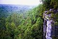
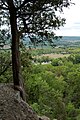
The Rattlesnake Point Conservation Area was established as a conservation area in 1961 by the Halton Region Conservation Authority.[3] It is a popular destination for hikers, backpackers, cyclists, rock climbers and nature-lovers in the Greater Toronto Area along with Mount Nemo Conservation Area. The park's ten kilometres of cliff edge and forest trails connect with the Bruce Trail and Crawford Lake.
Media in category "Rattlesnake Point Conservation Area"
The following 8 files are in this category, out of 8 total.
-
 Bruce-Trail-bmountain.jpg 460 × 307; 52 KB
-
 Caterpillar (2574655638).jpg 1,800 × 1,200; 1.96 MB
-
 Cliff Tree (2574655528).jpg 1,200 × 1,800; 1.84 MB
-
 Man walking through Rattlesnake Point.jpg 4,000 × 6,000; 2.11 MB
-
 Rattlesnake Point (45334957511).jpg 4,032 × 3,024; 3.03 MB
-
 Rattlesnake Point Conservation Area- Limestone Cliffs- Milton- Ontario.jpg 1,200 × 1,600; 1.03 MB
-

-
 Topographical Survey (3623622155).jpg 4,310 × 2,868; 6.32 MB

.jpg)
.jpg)

.jpg)

.jpg)