Category:Rail transport maps of Pays de la Loire
Jump to navigation
Jump to search
Administrative regions and territorial collectivity of Metropolitan France (‡ since start of 2016):
Auvergne-Rhône-Alpes‡ · Bourgogne-Franche-Comté‡ · Brittany · Centre-Val de Loire · Corsica · Grand Est‡ · Hauts-de-France‡ · Île-de-France · Normandy‡ · New Aquitaine‡ · Occitania‡ · Pays de la Loire · Provence-Alpes-Côte d'Azur
Overseas departments and regions: Réunion
Auvergne-Rhône-Alpes‡ · Bourgogne-Franche-Comté‡ · Brittany · Centre-Val de Loire · Corsica · Grand Est‡ · Hauts-de-France‡ · Île-de-France · Normandy‡ · New Aquitaine‡ · Occitania‡ · Pays de la Loire · Provence-Alpes-Côte d'Azur
Overseas departments and regions: Réunion
Subcategories
This category has the following 3 subcategories, out of 3 total.
Media in category "Rail transport maps of Pays de la Loire"
The following 37 files are in this category, out of 37 total.
-
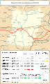
 Railway map of France - 44 - 1880 - fr - small.svg 705 × 985; 8.44 MB
-
 Railway map of France - 44 - 1900 - fr - small.svg 705 × 985; 8.56 MB
-
 Railway map of France - 44 - 1913 - fr - small.svg 705 × 985; 8.71 MB
-
 Railway map of France - 44 - 1932 - fr - small.svg 705 × 985; 8.77 MB
-
 Railway map of France - 44 - 1950 - fr - small.svg 705 × 985; 8.66 MB
-
 Railway map of France - 44 - 1980 - fr - small.svg 705 × 985; 8.66 MB
-
 Railway map of France - 44 - 2000 - fr - small.svg 705 × 985; 8.68 MB
-
 Railway map of France - 44 - 2020 - fr - small.svg 705 × 985; 8.52 MB
-
 Railway map of France - 44 - animated - fr.gif 1,566 × 2,188; 6.27 MB
-
 Railway map of France - 49 - 1880 - fr - small.svg 705 × 985; 9.29 MB
-
 Railway map of France - 49 - 1900 - fr - small.svg 705 × 985; 9.58 MB
-
 Railway map of France - 49 - 1913 - fr - small.svg 705 × 985; 9.67 MB
-
 Railway map of France - 49 - 1930 - fr - small.svg 705 × 985; 9.71 MB
-
 Railway map of France - 49 - 1980 - fr - small.svg 705 × 985; 9.56 MB
-
 Railway map of France - 49 - 2020 - fr - small.svg 705 × 985; 9.38 MB
-
 Railway map of France - 49 - animated - fr.gif 1,566 × 2,188; 6.46 MB
-
 Railway map of France - 53 - 1900 - fr - small.svg 564 × 933; 7.16 MB
-
 Railway map of France - 53 - 1930 - fr - small.svg 564 × 933; 7.28 MB
-
 Railway map of France - 53 - 1980 - fr - small.svg 564 × 933; 7.17 MB
-
 Railway map of France - 53 - 2020 - fr - small.svg 564 × 933; 6.99 MB
-
 Railway map of France - 53 - animated - fr.gif 1,246 × 2,061; 4.72 MB
-
 Railway map of France - 72 - 1900 - fr - small.svg 564 × 1,003; 7.16 MB
-
 Railway map of France - 72 - 1930 - fr - small.svg 564 × 1,003; 7.27 MB
-
 Railway map of France - 72 - 1980 - fr - small.svg 564 × 1,003; 7.17 MB
-
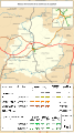 Railway map of France - 72 - 2020 - fr - small.svg 564 × 1,003; 7 MB
-
 Railway map of France - 72 - animated - fr.gif 1,252 × 2,227; 5.14 MB
-
 Railway map of France - 85 - 1900 - fr - small.svg 705 × 914; 7.54 MB
-
 Railway map of France - 85 - 1913 - fr - small.svg 705 × 914; 7.63 MB
-
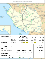 Railway map of France - 85 - 1930 - fr - small.svg 705 × 914; 7.67 MB
-
 Railway map of France - 85 - 1980 - fr - small.svg 705 × 914; 7.56 MB
-
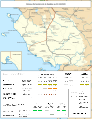 Railway map of France - 85 - 2020 - fr - small.svg 705 × 914; 7.37 MB
-
 Railway map of France - 85 - animated - fr.gif 1,566 × 2,030; 5.42 MB
-
 Railway map of France - Angers - animated - fr.gif 1,620 × 1,980; 11.2 MB
-
 Railway map of France - Le Mans - animated - fr.gif 1,802 × 1,691; 10.94 MB
-
 Railway map of France - Nantes - animated - fr.gif 1,624 × 1,947; 13.63 MB
-
 Railway map of France - PDL - 1930 - fr.svg 564 × 850; 8.53 MB
-
 Railway map of France - PDL - 2020 - fr.svg 564 × 850; 8.52 MB


