Category:Rail transport maps of Leipzig
Jump to navigation
Jump to search
Subcategories
This category has only the following subcategory.
G
- Gleispläne Leipzig-Plagwitz (33 F)
Media in category "Rail transport maps of Leipzig"
The following 18 files are in this category, out of 18 total.
-
 Citytunnel lpz.png 792 × 544; 161 KB
-
 Connewitz km3.521.gif 2,077 × 1,234; 152 KB
-
 Eilenburger Bahnhof 1884.jpg 640 × 578; 173 KB
-
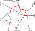 Güterring Leipzig.svg 500 × 440; 12 KB
-
 Karte City-Tunnel Leipzig.png 1,679 × 3,319; 2.74 MB
-
 Karte der Bahnstrecke Leipzig-Eilenburg.png 1,500 × 1,218; 1.03 MB
-
 Leipzig Stadtplan mit Umgebung 1892-1898.jpg 2,523 × 3,150; 1.52 MB
-
 Leipzig-1871-df dk 0006110.jpg 9,783 × 8,389; 16.98 MB
-
 Leipzig-Eutritzsch.gif 927 × 765; 118 KB
-
 Leipzig-Plagwitz-Industriebahnhof.jpg 432 × 702; 265 KB
-
 Leipzig-Plagwitz–Gaschwitz.png 310 × 436; 188 KB
-
 Leipzig-Wahren Leipzig Hbf.png 320 × 322; 171 KB
-
 Plan Leipzig 1863.jpg 1,983 × 1,478; 2.33 MB
-
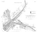
 Preußischer Freiladebahnhof Leipzig.jpg 1,212 × 1,604; 466 KB
-
 RA05.01SN-7-L14.jpg 8,332 × 6,457; 5.36 MB
-
 S-Bahn Leipzig bis 2002.JPG 832 × 784; 70 KB
-
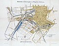
 Thüringer Bahnhof Karte 1860.jpg 640 × 488; 160 KB
-
 Umgestaltung der Bahnanlagen in und bei Leipzig.jpg 4,125 × 3,613; 4.21 MB


