Category:Radbourne
Jump to navigation
Jump to search
English: Radbourne is a small village and civil parish in the English county of Derbyshire, a few miles west of Derby.
village and civil parish in South Derbyshire District, Derbyshire, England  | |||||
| Upload media | |||||
| Instance of | |||||
|---|---|---|---|---|---|
| Location | South Derbyshire, Derbyshire, East Midlands, England | ||||
 | |||||
Subcategories
This category has the following 2 subcategories, out of 2 total.
A
- St Andrew's church, Radbourne (19 F)
R
- Radbourne Hall (2 F)
Media in category "Radbourne"
The following 200 files are in this category, out of 212 total.
(previous page) (next page)-
 A Broad Bean Crop - geograph.org.uk - 5456613.jpg 2,000 × 1,333; 2.69 MB
-
 A combine harvester at work in a field of wheat - geograph.org.uk - 6246353.jpg 1,280 × 960; 506 KB
-
 A country path - geograph.org.uk - 5497451.jpg 2,000 × 1,333; 2.85 MB
-
 A farm no more - geograph.org.uk - 5461943.jpg 2,000 × 1,333; 1.35 MB
-
 A field of oats - geograph.org.uk - 5497456.jpg 2,000 × 1,333; 2.68 MB
-
 A gate on the Derby Nomad Way - geograph.org.uk - 6246518.jpg 1,280 × 960; 616 KB
-
 A housing development - geograph.org.uk - 5461990.jpg 2,000 × 1,333; 1.88 MB
-
 A line of pylons - geograph.org.uk - 6244106.jpg 1,280 × 960; 303 KB
-
 A new development - geograph.org.uk - 6035505.jpg 2,000 × 1,333; 1.97 MB
-
 A stream near Radbourne - geograph.org.uk - 5519561.jpg 1,333 × 2,000; 3.24 MB
-
 A summer-evening walk - geograph.org.uk - 4536927.jpg 1,024 × 732; 1.06 MB
-
 Abandoned sleepers - geograph.org.uk - 312436.jpg 640 × 480; 118 KB
-
 Across the fields towards Etwall - geograph.org.uk - 4536901.jpg 1,024 × 731; 1,017 KB
-
 B5020 heading south east - geograph.org.uk - 4074107.jpg 640 × 480; 59 KB
-
 B5020 towards Mickleover - geograph.org.uk - 4074121.jpg 640 × 480; 58 KB
-
 Bannell's Lane - geograph.org.uk - 5604812.jpg 1,280 × 960; 625 KB
-
 Barn with hay and equipment - geograph.org.uk - 2263279.jpg 3,648 × 2,736; 6.01 MB
-
 Barn, Foxfields Farm - geograph.org.uk - 4913129.jpg 640 × 480; 75 KB
-
 Bend in lane - geograph.org.uk - 4041377.jpg 3,088 × 2,056; 4.6 MB
-
 Black Wood - geograph.org.uk - 312405.jpg 640 × 480; 114 KB
-
-
 Bonnie Prince Charlie Walk near Silverhill Farm - geograph.org.uk - 4285574.jpg 4,000 × 3,000; 1.91 MB
-
 Brickyard Wood - geograph.org.uk - 4074103.jpg 640 × 523; 145 KB
-
 Brickyard Wood Farm - geograph.org.uk - 2263237.jpg 3,648 × 2,736; 5.52 MB
-
 Brook - geograph.org.uk - 3035073.jpg 1,200 × 1,600; 505 KB
-
 Burnaston, Toyota Works, aerial 2014 - geograph.org.uk - 3926057.jpg 1,024 × 683; 94 KB
-
 Camomile in the field - geograph.org.uk - 5361658.jpg 2,000 × 1,333; 3.09 MB
-
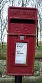 Close up, Elizabeth II postbox, Radbourne - geograph.org.uk - 4916114.jpg 1,504 × 2,958; 913 KB
-

-
 Coping Stone - geograph.org.uk - 312429.jpg 640 × 480; 113 KB
-
 Cottage in Radbourne - geograph.org.uk - 3612802.jpg 800 × 533; 116 KB
-
 Crop field, Radbourne Common - geograph.org.uk - 4074098.jpg 640 × 480; 79 KB
-
 Culvert under the Great Northern Greenway - geograph.org.uk - 5615409.jpg 1,280 × 960; 657 KB
-
 Cunnery Pond - geograph.org.uk - 291148.jpg 640 × 480; 103 KB
-
 Cunnery Pond, Radbourne - geograph.org.uk - 4913102.jpg 640 × 480; 92 KB
-

-

-
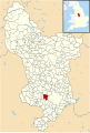 Derbyshire UK parish map highlighting Radbourne.svg 888 × 1,308; 2.35 MB
-
 Digging a trench - geograph.org.uk - 5681275.jpg 2,000 × 1,333; 2.1 MB
-
 Disc harrowing a harvested field - geograph.org.uk - 6253926.jpg 1,280 × 960; 719 KB
-
 Elizabeth II postbox, Radbourne - geograph.org.uk - 4916111.jpg 640 × 480; 140 KB
-
 Entering South Derbyshire - geograph.org.uk - 4074093.jpg 640 × 480; 83 KB
-
 Entrance to Bonnie Prince Charlie Walk - geograph.org.uk - 4039814.jpg 2,056 × 3,088; 4.69 MB
-
 Evening sunlight and rainclouds - geograph.org.uk - 4536912.jpg 1,024 × 731; 1.22 MB
-
 Evening sunlight near Mickleover - geograph.org.uk - 4536891.jpg 1,024 × 731; 1.06 MB
-
 Farm building, Brickyard Wood Farm - geograph.org.uk - 4074105.jpg 640 × 480; 46 KB
-
 Farm buildings at Radbourne - geograph.org.uk - 5386590.jpg 2,000 × 1,333; 2.85 MB
-
 Farm buildings, Park Farm, Radbourne - geograph.org.uk - 4913108.jpg 640 × 480; 63 KB
-
 Farm Houses near Radbourne - geograph.org.uk - 5386576.jpg 2,000 × 1,333; 2.02 MB
-

-
 Fence post - geograph.org.uk - 312425.jpg 640 × 480; 118 KB
-
 Field and Pylons near Long Lane - geograph.org.uk - 4202784.jpg 4,000 × 3,000; 3.21 MB
-
 Field by Pilldock Wood - geograph.org.uk - 2263330.jpg 3,648 × 2,736; 5.79 MB
-
 Field entrance and footpath - geograph.org.uk - 4913132.jpg 640 × 480; 84 KB
-
 Field entrance off Heage Lane - geograph.org.uk - 4912288.jpg 640 × 480; 80 KB
-
 Field near Potlocks Farm - geograph.org.uk - 4913096.jpg 640 × 480; 101 KB
-
 Field with pond near Mickleover - geograph.org.uk - 309899.jpg 640 × 480; 114 KB
-
 Fields in Radbourne Common - geograph.org.uk - 2263341.jpg 3,648 × 2,736; 5.4 MB
-
 Fields west of Mickleover - geograph.org.uk - 2396087.jpg 640 × 480; 78 KB
-
 Footbridge over a ditch under a hedge - geograph.org.uk - 6246404.jpg 1,280 × 960; 630 KB
-

-
 Footpath to Cherry Tree Farm passing a pylon - geograph.org.uk - 6246400.jpg 1,280 × 960; 411 KB
-
 Footpath to Mickleover - geograph.org.uk - 5497482.jpg 2,000 × 1,333; 2.77 MB
-

-
 Foxfields Farm - geograph.org.uk - 291149.jpg 640 × 480; 71 KB
-
 Foxfields Farm - geograph.org.uk - 3612708.jpg 800 × 533; 117 KB
-
 Foxfields Farm - geograph.org.uk - 3629876.jpg 4,000 × 2,248; 4.55 MB
-
 Foxfields Farm - geograph.org.uk - 5519564.jpg 2,000 × 1,333; 2.6 MB
-
 Gated entrance to Public Footpath - geograph.org.uk - 4039652.jpg 4,135 × 2,757; 6.47 MB
-
 Grazing beside The Rookery - geograph.org.uk - 4913078.jpg 640 × 480; 82 KB
-
 Grazing in Radbourne Park - geograph.org.uk - 4285534.jpg 4,000 × 3,000; 2.68 MB
-
 Grazing near Foxfields Farm - geograph.org.uk - 4913126.jpg 640 × 480; 85 KB
-
 Grazing, Radbourne - geograph.org.uk - 4913103.jpg 640 × 480; 65 KB
-
 Greenside Court, Mickleover, Derby - geograph.org.uk - 1813647.jpg 1,600 × 1,200; 419 KB
-
 Hay baling - geograph.org.uk - 6246362.jpg 1,280 × 960; 376 KB
-
 Heage Lane - geograph.org.uk - 4300537.jpg 4,000 × 3,000; 3.01 MB
-
 Hillside Farm , with binnies - geograph.org.uk - 2263327.jpg 3,648 × 2,736; 5.62 MB
-
 Hillside Farm - geograph.org.uk - 3501855.jpg 4,000 × 3,000; 3 MB
-
 House in Radbourne - geograph.org.uk - 3629886.jpg 3,988 × 2,226; 4.52 MB
-
 House near Foxfields Farm - geograph.org.uk - 4913109.jpg 640 × 480; 96 KB
-
 Houses being built - geograph.org.uk - 6108574.jpg 2,000 × 1,333; 1.74 MB
-
 Isla Close - geograph.org.uk - 6293686.jpg 2,000 × 1,330; 2.01 MB
-
 Ivy House Farm - geograph.org.uk - 2263230.jpg 3,322 × 2,539; 1.56 MB
-
 Ivy House Farm - geograph.org.uk - 4074119.jpg 640 × 480; 66 KB
-
 Jogger on Former Railway near Bonehill Gate - geograph.org.uk - 3787069.jpg 4,000 × 3,000; 2.6 MB
-
 Jogger on Former Railway Route - geograph.org.uk - 3787092.jpg 4,000 × 3,000; 2.7 MB
-
 Lane - geograph.org.uk - 3035066.jpg 1,600 × 1,200; 762 KB
-
 Lane Between Radbourne and Lees - geograph.org.uk - 291155.jpg 640 × 480; 69 KB
-
 Lane past The Slade Plantation - geograph.org.uk - 4041380.jpg 4,272 × 2,848; 7.74 MB
-
 Lone tree,somewhat damaged - geograph.org.uk - 2263249.jpg 2,945 × 2,186; 1.24 MB
-
 Looking over the hedge - geograph.org.uk - 5386558.jpg 2,000 × 1,333; 1.82 MB
-
 Looking towards the lake at Radbourne - geograph.org.uk - 5386606.jpg 2,000 × 1,333; 3.19 MB
-
 Lords and Ladies - geograph.org.uk - 5365889.jpg 2,000 × 1,333; 2.32 MB
-
 Maize field - geograph.org.uk - 3579599.jpg 2,256 × 1,504; 1.84 MB
-
 Mickleover Trail west of Mickleover (3) - geograph.org.uk - 6295423.jpg 1,024 × 768; 325 KB
-
 Mickleover Trail west of Mickleover (4) - geograph.org.uk - 6295426.jpg 1,024 × 768; 310 KB
-
 Mickleover Trail west of Mickleover (5) - geograph.org.uk - 6295442.jpg 1,024 × 768; 306 KB
-
 Mickleover Trail west of Mickleover (6) - geograph.org.uk - 6295477.jpg 1,024 × 768; 286 KB
-
 Mickleover Trail west of Mickleover (7) - geograph.org.uk - 6295488.jpg 1,024 × 768; 320 KB
-
 Mickleover Trail west of Mickleover (8) - geograph.org.uk - 6295495.jpg 1,024 × 768; 295 KB
-
 Mickleover, Howden Close on a midsummer evening - geograph.org.uk - 4536751.jpg 1,024 × 1,024; 1.12 MB
-
 Mickleover, Newhouse Farm - geograph.org.uk - 4536766.jpg 1,024 × 731; 1.04 MB
-
 Mickleover, towards Newhouse Farm - geograph.org.uk - 4536770.jpg 1,024 × 732; 1,024 KB
-
 Minor road near Silverhill Farm - geograph.org.uk - 4913101.jpg 640 × 480; 83 KB
-
 Minor road towards Lees - geograph.org.uk - 4913131.jpg 640 × 480; 76 KB
-
 Minor road towards Lees - geograph.org.uk - 4913133.jpg 640 × 480; 68 KB
-
 Minor road towards Mackworth - geograph.org.uk - 4913087.jpg 640 × 480; 105 KB
-
 Minor road towards Radbourne - geograph.org.uk - 4912294.jpg 640 × 480; 62 KB
-
 Minor road towards Radbourne - geograph.org.uk - 4913099.jpg 640 × 480; 83 KB
-
 Minor road, Radbourne - geograph.org.uk - 4913106.jpg 640 × 480; 77 KB
-
 Minor road, Radbourne - geograph.org.uk - 4916117.jpg 640 × 480; 92 KB
-
 Minor road, Radbourne - geograph.org.uk - 4916119.jpg 640 × 480; 101 KB
-
 More new houses - geograph.org.uk - 5635182.jpg 2,000 × 1,333; 902 KB
-
 More new houses - geograph.org.uk - 6003852.jpg 2,000 × 1,333; 2.33 MB
-
 More new houses - geograph.org.uk - 6293682.jpg 2,000 × 1,330; 1.74 MB
-
 Mown hay and hay bales - geograph.org.uk - 6244101.jpg 1,280 × 960; 411 KB
-
 Muddy path over the stream - geograph.org.uk - 312412.jpg 640 × 480; 118 KB
-
 Muddy path, footbridge over small stream - geograph.org.uk - 2841407.jpg 4,000 × 3,000; 2.69 MB
-
 Muddy road near Foxfields Farm - geograph.org.uk - 4913128.jpg 640 × 480; 102 KB
-
 Narrow Bridge - geograph.org.uk - 786328.jpg 640 × 480; 85 KB
-
 National Cycle Route 54 - geograph.org.uk - 2841414.jpg 4,000 × 3,000; 2.69 MB
-
 National Grid Pylons - geograph.org.uk - 3035061.jpg 1,600 × 1,200; 408 KB
-
 National trail route sign. - geograph.org.uk - 312397.jpg 480 × 640; 120 KB
-
 Near Greenside Court - geograph.org.uk - 5497471.jpg 2,000 × 1,333; 1.99 MB
-
 Near Radbourne - geograph.org.uk - 5519556.jpg 2,000 × 1,333; 2.91 MB
-
 Nearing Mickleover on a June evening - geograph.org.uk - 4536884.jpg 1,024 × 768; 1.21 MB
-
 New House Development - geograph.org.uk - 5461976.jpg 2,000 × 1,333; 1.07 MB
-
 New House Farm - geograph.org.uk - 5461946.jpg 2,000 × 1,333; 1.49 MB
-
 New House Farm - geograph.org.uk - 5461962.jpg 1,333 × 2,000; 1.29 MB
-
 New House Farm - geograph.org.uk - 5635177.jpg 2,000 × 1,333; 1.18 MB
-
 New House Farm farmhouse - geograph.org.uk - 5461951.jpg 1,333 × 2,000; 1.37 MB
-
 New House Farm Housing Development - geograph.org.uk - 5618282.jpg 2,000 × 1,258; 1.87 MB
-
 New House Farm. Mickleover - geograph.org.uk - 2396077.jpg 640 × 480; 76 KB
-
 New houses - geograph.org.uk - 5618803.jpg 2,000 × 1,333; 1.71 MB
-
 New houses in the rain - geograph.org.uk - 6293677.jpg 2,000 × 1,330; 1.81 MB
-
 New houses on the 4 acre site - geograph.org.uk - 5635180.jpg 2,000 × 1,333; 864 KB
-
 New houses on the way - geograph.org.uk - 5681263.jpg 2,000 × 1,333; 2.02 MB
-
 No problem path finding - geograph.org.uk - 2263245.jpg 1,600 × 1,200; 599 KB
-
 Oil Seed Rape in flower - geograph.org.uk - 5690086.jpg 2,000 × 1,333; 2.5 MB
-
 Old Railway Signal - geograph.org.uk - 312434.jpg 480 × 640; 119 KB
-
 On the Derby Nomad Walk - geograph.org.uk - 3610021.jpg 4,000 × 2,248; 5.69 MB
-
 Osierbed Wood - geograph.org.uk - 312422.jpg 640 × 480; 119 KB
-
 Path Approaching Radbourne Lane - geograph.org.uk - 4285614.jpg 4,000 × 3,000; 1.87 MB
-

-
 Path next to Radbourne Lane in Derbyshire - geograph.org.uk - 1813727.jpg 1,600 × 1,200; 468 KB
-
 Path next to Radbourne Lane in Derbyshire - geograph.org.uk - 1813753.jpg 1,600 × 1,200; 324 KB
-
 Path next to Radbourne Lane, Radbourne in Derbyshire - geograph.org.uk - 1813664.jpg 1,600 × 1,200; 455 KB
-
 Paxton Close - geograph.org.uk - 5618289.jpg 2,000 × 1,333; 2.8 MB
-
 Pheasants at Daysclose Plantation - geograph.org.uk - 6253938.jpg 1,280 × 960; 664 KB
-
 Pipes awaiting their trench - geograph.org.uk - 5681271.jpg 2,000 × 1,333; 2.26 MB
-
 Pond near Foxfields Farm - geograph.org.uk - 4913124.jpg 640 × 480; 84 KB
-
 Ponies grazing in field, Mickleover - geograph.org.uk - 2841399.jpg 4,000 × 3,000; 2.67 MB
-
 Potlocks Farm - geograph.org.uk - 2841425.jpg 4,000 × 3,000; 2.63 MB
-
 Potlocks Farm - geograph.org.uk - 291137.jpg 640 × 480; 67 KB
-
 Potlocks Farm - geograph.org.uk - 312401.jpg 640 × 480; 114 KB
-
 Potlocks Farm - geograph.org.uk - 6108557.jpg 2,000 × 1,333; 2.96 MB
-

-
 Potlocks Farm viewed from former Railway - geograph.org.uk - 3787051.jpg 3,922 × 2,894; 2.77 MB
-
 Public footpath to Radbourne - geograph.org.uk - 5615439.jpg 1,280 × 960; 777 KB
-
 Public Footpath towards Cherry Tree Farm - geograph.org.uk - 3880421.jpg 3,088 × 2,056; 2.89 MB
-

-
 Public footpath, Radbourne Common, Derbyshire - geograph.org.uk - 1820626.jpg 1,200 × 1,600; 230 KB
-

-
 Public Footpath, Radbourne, Derbyshire - geograph.org.uk - 1819749.jpg 1,600 × 1,200; 404 KB
-
 Radbourne Common, Derbyshire - geograph.org.uk - 1819744.jpg 1,600 × 1,200; 399 KB
-
 Radbourne Lane - geograph.org.uk - 4041426.jpg 3,088 × 2,056; 4.74 MB
-
 Radbourne Lane - geograph.org.uk - 4041430.jpg 3,088 × 2,056; 3.35 MB
-
 Radbourne Park - geograph.org.uk - 4285545.jpg 4,000 × 3,000; 2.44 MB
-
 Radbourne village, Derbyshire - geograph.org.uk - 1813691.jpg 1,600 × 1,200; 302 KB
-
 Radbourne, a July evening - geograph.org.uk - 4083045.jpg 1,024 × 777; 828 KB
-
 Radbourne, an evening walk - geograph.org.uk - 4760143.jpg 640 × 480; 110 KB
-
 Ridge and furrow field at Bean Hole Plantation - geograph.org.uk - 5615403.jpg 1,280 × 960; 783 KB
-

-
 Road and Public Footpath, Radbourne, Derbyshire - geograph.org.uk - 1819751.jpg 1,600 × 1,200; 355 KB
-
 Rough Pasture - geograph.org.uk - 5519573.jpg 2,000 × 1,333; 2.72 MB
-
 Rural Lane near Corner Farm - geograph.org.uk - 3501840.jpg 4,000 × 3,000; 2.29 MB
-
 School House, Radbourne, with postie - geograph.org.uk - 2263290.jpg 3,648 × 2,736; 6.35 MB
-
 Section of old road, closed off - geograph.org.uk - 2396092.jpg 640 × 480; 116 KB
-
 Sheep at Potlocks Farm - geograph.org.uk - 4537885.jpg 1,024 × 732; 1,017 KB
-
 Silverhill Farm - geograph.org.uk - 291142.jpg 640 × 480; 84 KB
-
 Snowdrops in a graveyard - geograph.org.uk - 2263316.jpg 3,648 × 2,736; 6.37 MB
-
 South Lodge - geograph.org.uk - 3738331.jpg 1,200 × 900; 326 KB
-
 South Lodge, Radbourne Hall - geograph.org.uk - 4913093.jpg 640 × 480; 116 KB
-

-
 Stile, hedge and footpath junction - geograph.org.uk - 2263240.jpg 3,648 × 2,736; 5.72 MB
-
 Still preparing the ground - geograph.org.uk - 6035500.jpg 2,000 × 1,294; 1.96 MB
-
 Sunrise - Summer Solstice 2010 - geograph.org.uk - 1932217.jpg 3,008 × 2,000; 2.45 MB
-
 Sustrans Cycle Route 54 - geograph.org.uk - 2158666.jpg 1,496 × 1,122; 882 KB
-
 Sustrans Cycle Route 54 - geograph.org.uk - 2158676.jpg 1,496 × 1,122; 1.12 MB
-

-
 The Derby Nomad Way near Foxfields Farm - geograph.org.uk - 3501826.jpg 4,000 × 3,000; 2.37 MB
-
 The end of Greenside Court - geograph.org.uk - 5618316.jpg 2,000 × 1,333; 2.56 MB
-
 The harvest is in - geograph.org.uk - 5519583.jpg 2,000 × 1,333; 2.48 MB
-
 The next phase - geograph.org.uk - 6003854.jpg 2,000 × 1,333; 2.07 MB
-
 The Oaks behind a field of sweetcorn - geograph.org.uk - 6253952.jpg 1,280 × 960; 444 KB
-
 The road to Radbourne - geograph.org.uk - 6108561.jpg 2,000 × 1,333; 3.16 MB
-
 The Rookery - geograph.org.uk - 4913079.jpg 640 × 480; 132 KB
-
 Towards Dunster's Plantation - geograph.org.uk - 4536915.jpg 1,024 × 731; 866 KB
-
 Towards Potlocks Farm - geograph.org.uk - 4537895.jpg 1,024 × 732; 1.02 MB
-
 Track near Foxfields Farm - geograph.org.uk - 4039671.jpg 4,272 × 2,848; 7.12 MB


_-_geograph.org.uk_-_4911992.jpg)


_-_geograph.org.uk_-_6295423.jpg)
_-_geograph.org.uk_-_6295426.jpg)
_-_geograph.org.uk_-_6295442.jpg)
_-_geograph.org.uk_-_6295477.jpg)
_-_geograph.org.uk_-_6295488.jpg)
_-_geograph.org.uk_-_6295495.jpg)


_-_geograph.org.uk_-_1819777.jpg)


