Category:Queen Insurance Buildings, Dale Street
Jump to navigation
Jump to search
| Object location | | View all coordinates using: OpenStreetMap |
|---|
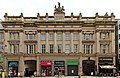
building in Liverpool, Merseyside, UK  6-10, Dale Street | |||||
| Upload media | |||||
| Instance of | |||||
|---|---|---|---|---|---|
| Location | Liverpool, Merseyside, North West England, England | ||||
| Heritage designation |
| ||||
 | |||||
6 - 10 Dale Street, Liverpool Grade II listed stone office buildings, by Samuel Rowland. Built 1839 for the Royal Bank, with entrances to Sweeting Street and Queen Avenue. Formerly listed by English Heritage as Nos. 8 - 12.
Subcategories
This category has only the following subcategory.
Media in category "Queen Insurance Buildings, Dale Street"
The following 7 files are in this category, out of 7 total.
-
 6-10, Dale Street.jpg 3,000 × 4,000; 3.44 MB
-

-
 Plaque on Queen Insurance Buildings, Dale Street.jpg 2,352 × 2,604; 2.51 MB
-
 Queen Insurance Building on Dale Street 1.JPG 1,446 × 1,902; 442 KB
-
 Queen Insurance Buildings 1.jpg 4,431 × 2,880; 5.42 MB
-
 Queen Insurance Buildings, Dale Street, Liverpool.jpg 640 × 470; 166 KB
-
 Royal Coat of Arms, Queen Insurance Building, Dale Street.jpg 5,078 × 3,336; 7.28 MB


