Category:Protestantse kerk (Kolderveen)
Jump to navigation
Jump to search
| Object location | | View all coordinates using: OpenStreetMap |
|---|
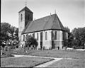
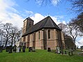
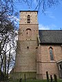
church building in Meppel, Netherlands  | |||||
| Upload media | |||||
| Instance of | |||||
|---|---|---|---|---|---|
| Location |
| ||||
| Street address |
| ||||
| Heritage designation |
| ||||
| Inception |
| ||||
| Significant event |
| ||||
| official website | |||||
 | |||||
Nederlands: Protestantse kerk - Anno 1471
|
This is a category about rijksmonument number 30962
|
| Address |
|
Media in category "Protestantse kerk (Kolderveen)"
The following 23 files are in this category, out of 23 total.
-
 Avondmaalsbeker - Kolderveen - 20126291 - RCE.jpg 767 × 960; 96 KB
-
 Exterieur - Kolderveen - 20126286 - RCE.jpg 1,200 × 843; 261 KB
-
 Exterieur - Kolderveen - 20126287 - RCE.jpg 1,200 × 937; 282 KB
-
 Exterieur naar het noord-westen - Kolderveen - 20126288 - RCE.jpg 1,200 × 959; 284 KB
-
 Exterieur OVERZICHT ZUIDOOST GEVEL - Kolderveen - 20263416 - RCE.jpg 782 × 1,200; 273 KB
-
 Exterieur zuidkant.JPG 3,264 × 2,448; 4.33 MB
-
 Exterieur zuidoostkant.JPG 3,264 × 2,448; 3.48 MB
-
 Herfoarme tsjerke fan Kolderfean.jpg 2,000 × 1,334; 1.93 MB
-
 Interieur met orgel naar het westen - Kolderveen - 20126290 - RCE.jpg 959 × 1,200; 207 KB
-
 Interieur naar het oosten - Kolderveen - 20126289 - RCE.jpg 959 × 1,200; 198 KB
-
 Interieur naar het oosten - Kolderveen - 20126298 - RCE.jpg 960 × 1,200; 158 KB
-
 Interieur naar het westen - Kolderveen - 20126299 - RCE.jpg 1,200 × 960; 176 KB
-
 Interieur, aanzicht orgel, orgelnummer 1898 - Kolderveen - 20369342 - RCE.jpg 922 × 1,200; 174 KB
-
 Kerk Kolderveen.jpg 800 × 533; 124 KB
-
 N.H.kerk (BERGHOK) PMVD F 295-2 - Kolderveen - 20491476 - RCE.jpg 1,200 × 900; 201 KB
-
 Noordgevel - Kolderveen - 20126297 - RCE.jpg 1,200 × 950; 336 KB
-
 Orgel - Kolderveen - 20126300 - RCE.jpg 1,200 × 960; 170 KB
-
 Overzicht noordgevel - Kolderveen - 20126296 - RCE.jpg 960 × 1,200; 430 KB
-
 Overzicht zuid-oost zijde - Kolderveen - 20126294 - RCE.jpg 1,200 × 960; 465 KB
-
 Overzicht zuidgevel - Kolderveen - 20126295 - RCE.jpg 1,200 × 955; 324 KB
-
 Thijs van Urklaan richting zuiden.JPG 3,264 × 2,448; 3.83 MB
-
 Toren zuidgevel.JPG 2,448 × 3,264; 4.1 MB
-
 Torenkruis.JPG 3,264 × 2,448; 3.66 MB


_PMVD_F_295-2_-_Kolderveen_-_20491476_-_RCE.jpg)


