Category:Prinsessegracht 28, The Hague
Jump to navigation
Jump to search
| Object location | | View all coordinates using: OpenStreetMap |
|---|
building in The Hague, Netherlands  | |||||
| Upload media | |||||
| Instance of | |||||
|---|---|---|---|---|---|
| Location | The Hague, South Holland, Netherlands | ||||
| Street address |
| ||||
| Located on street | |||||
| Heritage designation |
| ||||
 | |||||
|
This is a category about rijksmonument number 17954
|
| Address |
|
Media in category "Prinsessegracht 28, The Hague"
The following 21 files are in this category, out of 21 total.
-

-
 Achterkamer, 2e verdieping - 's-Gravenhage - 20090168 - RCE.jpg 957 × 1,200; 181 KB
-
 Achterkamer, links boven - 's-Gravenhage - 20090167 - RCE.jpg 952 × 1,200; 212 KB
-
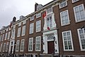
 Den Haag - Prinsessegracht 28.JPG 3,581 × 3,056; 2.67 MB
-
 Exterieur - 's-Gravenhage - 20090160 - RCE.jpg 945 × 1,200; 220 KB
-
 Exterieur - 's-Gravenhage - 20090161 - RCE.jpg 941 × 1,200; 264 KB
-
 Franse Ambassade - 's-Gravenhage - 20090159 - RCE.jpg 1,200 × 957; 279 KB
-
 Franse Ambassade, voorgevel - 's-Gravenhage - 20090158 - RCE.jpg 1,200 × 884; 275 KB
-
 Gedenkmonument voor Turkse ambassade, Den Haag.JPG 2,592 × 3,888; 4.7 MB
-
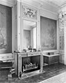
 Interieur linker tuinkamer - 's-Gravenhage - 20090165 - RCE.jpg 1,200 × 943; 254 KB
-
 Overzicht - 's-Gravenhage - 20090057 - RCE.jpg 1,200 × 949; 234 KB
-
 Overzicht - 's-Gravenhage - 20090123 - RCE.jpg 1,200 × 803; 199 KB
-
 Overzicht voorgevel - 's-Gravenhage - 20090114 - RCE.jpg 848 × 1,200; 266 KB
-
 Rechter tuinkamer - 's-Gravenhage - 20090162 - RCE.jpg 948 × 1,200; 218 KB
-
 Rechter tuinkamer - 's-Gravenhage - 20090170 - RCE.jpg 957 × 1,200; 211 KB
-
-
 Stadsbeeld - 's-Gravenhage - 20090061 - RCE.jpg 1,200 × 897; 251 KB
-
 Stallen vanuit de tuin Prinsessegracht 29 - 's-Gravenhage - 20090156 - RCE.jpg 1,200 × 885; 238 KB
-
 Tuinkamer rechts - 's-Gravenhage - 20090166 - RCE.jpg 943 × 1,200; 287 KB
-
 Turkse ambassade, Den Haag.JPG 3,888 × 2,592; 4.08 MB
-
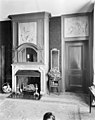
 Voorkamer, links schoorsteen - 's-Gravenhage - 20090164 - RCE.jpg 952 × 1,200; 216 KB


