Category:Political maps of India
Jump to navigation
Jump to search
Countries of Asia: Afghanistan · Azerbaijan‡ · Bangladesh · Cambodia · People's Republic of China · Cyprus‡ · East Timor · Egypt‡ · Georgia‡ · India · Indonesia‡ · Iran · Iraq · Japan · Jordan · Kazakhstan‡ · Kyrgyzstan · Laos · Lebanon · Malaysia · Maldives · Mongolia · Nepal · Pakistan · Philippines · Qatar · Russia‡ · Singapore · South Korea · Sri Lanka · Syria · Thailand · Turkey‡ · Vietnam
Limited recognition: Taiwan · South Ossetia‡ – Other territories: Macau
‡: partly located in Asia
Limited recognition: Taiwan · South Ossetia‡ – Other territories: Macau
‡: partly located in Asia
Subcategories
This category has the following 9 subcategories, out of 9 total.
Media in category "Political maps of India"
The following 76 files are in this category, out of 76 total.
-
 27novfinal.png 512 × 583; 58 KB
-
 Bharatiya Janata Party in states.png 1,594 × 1,868; 212 KB
-
 Chief Ministers of Indian States by Party (tam).png 904 × 1,008; 139 KB
-
 Communist Parties of India in states.png 1,486 × 1,734; 267 KB
-
 Delimitation Map india.jpg 1,280 × 1,494; 152 KB
-
 Dipanjan map.png 3,818 × 4,600; 1.24 MB
-
 GouvÉtats.jpg 1,519 × 1,733; 428 KB
-
 India 2021.jpg 1,449 × 1,689; 181 KB
-
 India CM Political Map.png 10,000 × 11,382; 1.97 MB
-
 India Disputed Areas.PNG 530 × 599; 135 KB
-
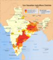 India Naxal affected districts map de.png 1,707 × 1,930; 607 KB
-
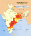 India Red Corridor map.png 530 × 599; 369 KB
-
 India ruiling parties.png 3,515 × 4,083; 602 KB
-
 India State Governments by alliance.png 3,818 × 4,600; 635 KB
-
 India, Pakistan and disputed Kashmir.jpg 5,442 × 4,021; 641 KB
-
 India-map-ml-political-parties-2017.png 5,011 × 5,623; 2.07 MB
-
 India-States-Separatism.PNG 513 × 600; 53 KB
-
 Indian Map as per Ruling Party.png 3,818 × 4,600; 1.01 MB
-
 Indian Parliament Seats 2026 Map.png 1,486 × 1,734; 343 KB
-
 Indian Political Map March 2022.png 3,818 × 4,600; 857 KB
-
 Indian state governments led by various political parties.png 1,486 × 1,734; 318 KB
-
 Indian States & Union Territories by HDI (2018) .png 3,818 × 4,600; 997 KB
-
 Indian states according to party of their chief minister 17.png 2,000 × 2,344; 364 KB
-
 Indian states according to party of their chief minister 18.png 800 × 938; 81 KB
-
 Indian states according to party of their chief minister ASDS.png 1,486 × 1,734; 309 KB
-
 Indian states according to party of their chief minister.png 1,486 × 1,734; 262 KB
-
 Indian states according to party of their chief ministers 17.png 1,486 × 1,734; 318 KB
-
 Indian states according to party of their chief ministers.png 1,486 × 1,734; 308 KB
-
 Indian States according to Ruling Parties (Assembly Elections).png 3,818 × 4,600; 997 KB
-
 Indian states according to the party of their chief minister.png 1,486 × 1,734; 262 KB
-
 Indian states according to the party of their cm.png 1,486 × 1,734; 309 KB
-
 Indian states as per ruling parties.png 1,486 × 1,734; 282 KB
-
 Indian states by cm party.png 1,486 × 1,734; 317 KB
-
 Indian states by Party Alliances 1.png 904 × 1,008; 140 KB
-
 Indian states by Party Alliances 2017.png 904 × 1,008; 140 KB
-
 Indian states by Party Alliances.png 904 × 1,008; 140 KB
-
 Indian states by political parties corrected1.png 510 × 593; 85 KB
-
 Indian states by political parties.PNG 514 × 600; 67 KB
-
 Indian states by Ruling Party 1.png 904 × 1,008; 140 KB
-
 Indian states by ruling party 2.png 1,486 × 1,734; 329 KB
-
 Indian states by Ruling Party 2017.png 904 × 1,008; 140 KB
-
 Indian states by ruling party.png 1,486 × 1,734; 272 KB
-
 Indian states by Ruling Party.png 904 × 1,008; 139 KB
-
 Indian states Chief Ministers by party (present).png 1,472 × 1,008; 152 KB
-
 Indian states.png 1,200 × 1,200; 150 KB
-
 IndiaStateGovernmentsAlliance.png 3,818 × 4,600; 635 KB
-
 JAN 2024.png 3,818 × 4,600; 1.1 MB
-
 Lok Sabha Election Dates by Location.jpg 1,096 × 1,375; 376 KB
-
 Loksabha and Rajyasabha seats.jpg 1,663 × 2,048; 148 KB
-
 MapChart Map cmfei5Ma.png 3,977 × 6,000; 682 KB
-
 MNS violence map.svg 1,639 × 1,852; 1.06 MB
-
 Naxaliten in Indien 2013.png 1,578 × 1,738; 619 KB
-
 Niyamasabha constituency map - Alappuzha district.jpg 669 × 993; 345 KB
-
 Niyamasabha constituency map - Ernakulam district.jpg 648 × 422; 241 KB
-
 Niyamasabha constituency map - Idukki district.jpg 655 × 925; 340 KB
-
 Niyamasabha constituency map - Kannur district.jpg 804 × 568; 261 KB
-
 Niyamasabha constituency map - Kasaragod district.jpg 649 × 1,069; 377 KB
-
 Niyamasabha constituency map - Kollam district.jpg 879 × 591; 395 KB
-
 Niyamasabha constituency map - Kottayam district.jpg 877 × 669; 475 KB
-
 Niyamasabha constituency map - Kozhikode district.jpg 649 × 952; 406 KB
-
 Niyamasabha constituency map - Malappuram district.jpg 641 × 912; 430 KB
-
 Niyamasabha constituency map - Palakkad district.jpg 660 × 923; 394 KB
-
 Niyamasabha constituency map - Pathananmthitta district.jpg 804 × 538; 276 KB
-
 Niyamasabha constituency map - Thiruvananthapuram district.jpg 729 × 510; 251 KB
-
 Niyamasabha constituency map - Thrissur district.jpg 850 × 562; 319 KB
-
 Niyamasabha constituency map - Wayanad district.jpg 760 × 533; 189 KB
-
 PotentialSuperpowers.png 1,427 × 628; 24 KB
-
 Presidents by state of birth.png 1,126 × 1,354; 230 KB
-
 Regierungsparteien Indien 1992-01-01 de.svg 850 × 907; 951 KB
-
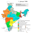 Regierungsparteien Indien 1996-01-01 de.svg 850 × 907; 952 KB
-
 Ruling Alliance in India.png 3,818 × 4,600; 1.15 MB
-
 Ruling Alliances in India 41223.jpg 1,080 × 1,286; 423 KB
-
 Ruling Parties in States and UT's of India as of December 2019.jpg 1,080 × 1,213; 237 KB
-
 Ruling party in Indian states.png 1,486 × 1,734; 255 KB
-
 State and union territory level parties map.png 597 × 700; 76 KB
-
 StateAssembliesJuly2022.png 800 × 939; 94 KB


.png)


_.png)


.png)


.png)


