Category:Political maps of Fairfield County, Ohio as of the 2000 United States Census
Jump to navigation
Jump to search
Media in category "Political maps of Fairfield County, Ohio as of the 2000 United States Census"
The following 35 files are in this category, out of 35 total.
-
 Map of Fairfield County Ohio Highlighting Amanda Township.png 527 × 564; 25 KB
-
 Map of Fairfield County Ohio Highlighting Amanda Village.png 527 × 564; 25 KB
-
 Map of Fairfield County Ohio Highlighting Baltimore Village.png 527 × 564; 25 KB
-
 Map of Fairfield County Ohio Highlighting Berne Township.png 527 × 564; 26 KB
-
 Map of Fairfield County Ohio Highlighting Bloom Township.png 527 × 564; 26 KB
-
 Map of Fairfield County Ohio Highlighting Bremen Village.png 527 × 564; 25 KB
-
 Map of Fairfield County Ohio Highlighting Buckeye Lake Village.png 527 × 564; 25 KB
-
 Map of Fairfield County Ohio Highlighting Canal Winchester City.png 527 × 564; 25 KB
-
 Map of Fairfield County Ohio Highlighting Carroll Village.png 527 × 564; 25 KB
-
 Map of Fairfield County Ohio Highlighting Clearcreek Township.png 527 × 564; 25 KB
-
 Map of Fairfield County Ohio Highlighting Columbus City.png 527 × 564; 25 KB
-
 Map of Fairfield County Ohio Highlighting Greenfield Township.png 527 × 564; 26 KB
-
 Map of Fairfield County Ohio Highlighting Hocking Township.png 527 × 564; 25 KB
-
 Map of Fairfield County Ohio Highlighting Lancaster City.png 527 × 564; 26 KB
-
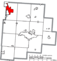
 Map of Fairfield County Ohio Highlighting Liberty Township.png 527 × 564; 26 KB
-
 Map of Fairfield County Ohio Highlighting Lithopolis Village.png 527 × 564; 25 KB
-
 Map of Fairfield County Ohio Highlighting Madison Township.png 527 × 564; 25 KB
-
 Map of Fairfield County Ohio Highlighting Millersport Village.png 527 × 564; 25 KB
-
 Map of Fairfield County Ohio Highlighting Pickerington City.png 527 × 564; 25 KB
-
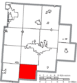
 Map of Fairfield County Ohio Highlighting Pleasant Township.png 527 × 564; 26 KB
-
 Map of Fairfield County Ohio Highlighting Pleasantville Village.png 527 × 564; 25 KB
-
 Map of Fairfield County Ohio Highlighting Reynoldsburg City.png 527 × 564; 25 KB
-
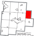 Map of Fairfield County Ohio Highlighting Richland Township.png 527 × 564; 26 KB
-
 Map of Fairfield County Ohio Highlighting Rush Creek Township.png 527 × 564; 26 KB
-
 Map of Fairfield County Ohio Highlighting Rushville Village.png 527 × 564; 25 KB
-
 Map of Fairfield County Ohio Highlighting Stoutsville Village.png 527 × 564; 25 KB
-
 Map of Fairfield County Ohio Highlighting Sugar Grove Village.png 527 × 564; 25 KB
-
 Map of Fairfield County Ohio Highlighting Tarlton Village.png 527 × 564; 25 KB
-
 Map of Fairfield County Ohio Highlighting Thurston Village.png 527 × 564; 25 KB
-
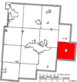
 Map of Fairfield County Ohio Highlighting Violet Township.png 527 × 564; 25 KB
-
 Map of Fairfield County Ohio Highlighting Walnut Township.png 527 × 564; 26 KB
-
 Map of Fairfield County Ohio Highlighting West Rushville Village.png 527 × 564; 25 KB
-
 Map of Fairfield County Ohio With Municipal and Township Labels.PNG 527 × 564; 53 KB
-
 Map of Fairfield County, Ohio No Text, Municipalities Distinct.png 527 × 564; 25 KB
-
 Map of Fairfield County, Ohio No Text.png 527 × 564; 25 KB


