Category:Pointon
Jump to navigation
Jump to search
village in United Kingdom  | |||||
| Upload media | |||||
| Instance of | |||||
|---|---|---|---|---|---|
| Location | Pointon and Sempringham, South Kesteven, Lincolnshire, East Midlands, England | ||||
| Different from | |||||
 | |||||
English: Pointon is a small village situated near Bourne, with a pub called "The Old Ship Inn" There is a thriving football team associated with the Sports and Social Club in the village with three adult teams and a range of age groups at junior level. The teams are managed by Trevor Hewson, Marlon Wan and Murray Turner, with the aid of many dedicated assistants].
Subcategories
This category has the following 2 subcategories, out of 2 total.
C
- Christchurch, Pointon (4 F)
L
- Little Wisbeach (6 F)
Media in category "Pointon"
The following 30 files are in this category, out of 30 total.
-

-
 Millthorpe crossroads, Pointon, Lincs - geograph.org.uk - 215128.jpg 640 × 480; 258 KB
-
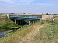 Neslam Bridge, Pointon, Lincs - geograph.org.uk - 215183.jpg 640 × 480; 351 KB
-
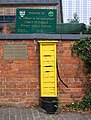 Parish pump, Pointon, Lincs - geograph.org.uk - 215135.jpg 486 × 640; 379 KB
-
-
 The Old Ship Inn, Pointon, Lincs - geograph.org.uk - 215130.jpg 640 × 480; 267 KB
-
 The parish pump at Pointon, near Bourne, Lincolnshire - geograph.org.uk - 4471514.jpg 1,758 × 1,178; 961 KB
-
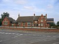
 Village school at Pointon, near Bourne, Lincolnshire - geograph.org.uk - 4360031.jpg 1,762 × 1,188; 841 KB
-
 Water at St Gilbert's Well - geograph.org.uk - 3994444.jpg 640 × 533; 206 KB
-
 West Road near Pointon - geograph.org.uk - 2898676.jpg 1,280 × 853; 796 KB
-
 Aslackby Decoy Farm, Aslackby Fen - geograph.org.uk - 280964.jpg 640 × 480; 89 KB
-
 Broad Drove, Surfleet Fen (1) - geograph.org.uk - 421398.jpg 640 × 427; 89 KB
-
 Crown Farm Cottages, Pointon Fen - geograph.org.uk - 277967.jpg 640 × 480; 65 KB
-
 Farm buildings (Pointon Cottage Farm) - geograph.org.uk - 277952.jpg 640 × 480; 102 KB
-
 Farmland by the South Forty Foot Drain - geograph.org.uk - 420805.jpg 640 × 427; 124 KB
-
 Farmland on Surfleet Fen - geograph.org.uk - 420800.jpg 640 × 427; 94 KB
-
 Farmland, Neslam Fen, Pointon, Lincs - geograph.org.uk - 215161.jpg 640 × 480; 356 KB
-
 Farmland, Sempringham Fen, Lincs - geograph.org.uk - 215159.jpg 640 × 480; 318 KB
-
 Fen Road, Pointon Fen - geograph.org.uk - 450538.jpg 640 × 480; 83 KB
-
 Forty Foot Farm, Pointon Fen - geograph.org.uk - 277968.jpg 640 × 480; 72 KB
-
 Forty Foot Farm, Pointon Fen - geograph.org.uk - 278431.jpg 640 × 480; 66 KB
-
 Goats do roam - geograph.org.uk - 450539.jpg 640 × 480; 112 KB
-

-
 High Bunning Lane Airstrip, Pointon - geograph.org.uk - 277956.jpg 640 × 480; 113 KB
-
 Neslam Farm and air strip, Neslam Fen - geograph.org.uk - 278425.jpg 640 × 480; 61 KB
-
 Neslam Farm, Neslam Fen - geograph.org.uk - 277961.jpg 640 × 480; 79 KB
-
 Neslam Road, Neslam Fen, Pointon, Lincs - geograph.org.uk - 215182.jpg 640 × 480; 257 KB
-

-
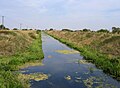
 Sempringham Lode - geograph.org.uk - 450537.jpg 640 × 480; 115 KB
-


_-_geograph.org.uk_-_421398.jpg)

_-_geograph.org.uk_-_277952.jpg)


