Category:Playing fields in London
Jump to navigation
Jump to search
Subcategories
This category has the following 12 subcategories, out of 12 total.
E
H
K
L
- Lillie Bridge Grounds (6 F)
- Lyttelton Playing Fields (21 F)
N
- North Acton Playing Field (3 F)
P
- Purley Way Playing Fields (9 F)
R
V
- Vincent Square playing fields (10 F)
W
- The Warren (Hayes) (4 F)
Media in category "Playing fields in London"
The following 94 files are in this category, out of 94 total.
-
 Barn Elms Playing Fields - geograph.org.uk - 2057697.jpg 3,296 × 2,472; 1.8 MB
-
 Barn Elms Playing Fields - geograph.org.uk - 2399284.jpg 1,000 × 667; 180 KB
-
 Barn Elms Recreation Ground - geograph.org.uk - 789523.jpg 640 × 430; 79 KB
-
 Barnes Elm recreation Ground - geograph.org.uk - 789535.jpg 640 × 430; 65 KB
-

-
 Berkeley Fields - geograph.org.uk - 188754.jpg 640 × 480; 105 KB
-
 Bow Lane Playing Fields - geograph.org.uk - 163869.jpg 640 × 480; 128 KB
-
 Bow Lane Playing Fields - geograph.org.uk - 973784.jpg 640 × 427; 125 KB
-
 Charlton Park - geograph.org.uk - 262019.jpg 640 × 480; 26 KB
-
 Chiswick Sunset - geograph.org.uk - 800812.jpg 640 × 480; 27 KB
-
 Colfeian Sports Club - geograph.org.uk - 127585.jpg 640 × 480; 152 KB
-
 Corner of St Paul's School playing field - geograph.org.uk - 3656735.jpg 640 × 482; 105 KB
-
 Cricket pavilion, The Paulin Ground - geograph.org.uk - 9237.jpg 640 × 480; 117 KB
-
 Cricket Pitch, Whitgift School - geograph.org.uk - 2320862.jpg 640 × 430; 84 KB
-
 Dulwich College Pavilion - geograph.org.uk - 2633960.jpg 4,288 × 3,216; 6.39 MB
-
 Dulwich College playing fields - geograph.org.uk - 5681747.jpg 640 × 426; 62 KB
-
 Dulwich College playing fields - geograph.org.uk - 5828733.jpg 1,024 × 681; 160 KB
-
 Dulwich College school field - geograph.org.uk - 3850008.jpg 2,560 × 1,920; 1.92 MB
-
 Ealing Hospital - north elevation - geograph.org.uk - 1049575.jpg 640 × 480; 51 KB
-

-
 Elthorne Park playing fields - geograph.org.uk - 587338.jpg 640 × 480; 76 KB
-
 Enfield Playing Fields, Enfield - geograph.org.uk - 334497.jpg 640 × 480; 115 KB
-
 Fairfield - geograph.org.uk - 151394.jpg 640 × 480; 69 KB
-
 Football match, Wanstead Flats - geograph.org.uk - 1593630.jpg 640 × 480; 79 KB
-
 Football on North Acton recreation ground - geograph.org.uk - 170894.jpg 640 × 479; 148 KB
-

-

-
 Football pitch, Coulsdon Common, Surrey - geograph.org.uk - 56944.jpg 640 × 480; 107 KB
-
 Football pitch, Forty Tree Green - geograph.org.uk - 753777.jpg 640 × 480; 97 KB
-

-

-
 Gibbons Recreation Ground, London NW10.jpg 3,264 × 2,448; 780 KB
-
 Harrow College Playing Fields, London Borough of Harrow, HA1 (1234343247).jpg 1,280 × 960; 316 KB
-

-
 Hockey Pitches, Ruislip - geograph.org.uk - 89841.jpg 640 × 480; 144 KB
-
 Horsenden Hill playing fields - geograph.org.uk - 678568.jpg 640 × 480; 149 KB
-

-
 John Billam sports ground, Kenton - geograph.org.uk - 99163.jpg 640 × 478; 53 KB
-
 Joseph Hood Playing Fields - geograph.org.uk - 23378.jpg 640 × 480; 51 KB
-
 King George V Playing Field - geograph.org.uk - 630547.jpg 640 × 465; 91 KB
-
 Latymer Upper Playing Fields - geograph.org.uk - 681326.jpg 640 × 480; 56 KB
-
 Muswell Hill Sports Ground - geograph.org.uk - 240923.jpg 640 × 480; 83 KB
-
 Muswell Hill Sports Ground - geograph.org.uk - 240933.jpg 640 × 480; 124 KB
-

-

-
 Old Cholmeleians - geograph.org.uk - 385671.jpg 640 × 480; 92 KB
-

-
 Park Football in Gunnersbury - geograph.org.uk - 63993.jpg 640 × 451; 62 KB
-
 Pavilion, Whitgift School - geograph.org.uk - 2164905.jpg 640 × 430; 122 KB
-
 Playing field - geograph.org.uk - 1020951.jpg 640 × 480; 92 KB
-
 Playing field - geograph.org.uk - 1069042.jpg 640 × 416; 70 KB
-

-

-
 Playing field, Whitgift School - geograph.org.uk - 2164897.jpg 640 × 430; 118 KB
-
 Playing fields - Whitgift School - geograph.org.uk - 2344977.jpg 640 × 430; 59 KB
-

-

-

-
 Playing Fields beside Hampstead Lane - geograph.org.uk - 401255.jpg 640 × 480; 135 KB
-

-
 Playing Fields off Lower Road, Harrow - geograph.org.uk - 175024.jpg 640 × 480; 96 KB
-
 Playing Fields, Putney Vale - geograph.org.uk - 29444.jpg 640 × 480; 69 KB
-
 Playing Fields, Ruislip - geograph.org.uk - 89837.jpg 640 × 480; 140 KB
-
 Playing fields, St Paul's School, Barnes - geograph.org.uk - 2129163.jpg 640 × 480; 107 KB
-
 Playing Fields, Wembley - geograph.org.uk - 330986.jpg 640 × 480; 87 KB
-
 Rayners Lane, Roxbourne Park - geograph.org.uk - 81929.jpg 640 × 480; 96 KB
-
 Redundant Roller - geograph.org.uk - 1657458.jpg 640 × 428; 51 KB
-

-
 Snow on North Acton playing fields - geograph.org.uk - 1625152.jpg 640 × 479; 50 KB
-
 Sports field in Battersea Park - geograph.org.uk - 2336474.jpg 1,500 × 1,000; 154 KB
-
 Sports Field, Whitgift School - geograph.org.uk - 2153105.jpg 640 × 430; 159 KB
-
-
 Sports Ground - geograph.org.uk - 75322.jpg 640 × 480; 55 KB
-

-
 Sports ground, Dulwich College - geograph.org.uk - 1936064.jpg 640 × 430; 134 KB
-

-
 St Paul's School, Hammersmith - geograph.org.uk - 2129211.jpg 640 × 480; 58 KB
-
 Stanley Road - geograph.org.uk - 158011.jpg 480 × 640; 112 KB
-
 Stanley Road Playing Fields - geograph.org.uk - 1626520.jpg 396 × 640; 147 KB
-
 Sunday morning Rugby. - geograph.org.uk - 127586.jpg 640 × 480; 139 KB
-

-

-
 Sunset over West Hendon Playing Fields - geograph.org.uk - 4246025.jpg 2,224 × 1,614; 955 KB
-
 The Pavilion, Lyttleton Playing Fields - geograph.org.uk - 943485.jpg 640 × 427; 145 KB
-
 Trinity School - geograph.org.uk - 2449686.jpg 640 × 430; 76 KB
-

-

-
 Wembley Stadium Arch under construction - geograph.org.uk - 16166.jpg 640 × 633; 105 KB
-
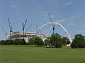 Wembley Stadium under construction - geograph.org.uk - 16167.jpg 640 × 480; 84 KB
-
 West Hendon Playing Fields - geograph.org.uk - 4246022.jpg 2,304 × 1,728; 876 KB
-
 WestActonPSplayingfield.jpg 3,648 × 2,736; 3.54 MB
-

-
 Willesden Sports Centre - geograph.org.uk - 1275215.jpg 640 × 480; 60 KB
-
 Wycombe House Club - geograph.org.uk - 301776.jpg 640 × 426; 94 KB


.jpg)


_-_geograph.org.uk_-_251607.jpg)


