Category:Plans of fortifications in the United States
Jump to navigation
Jump to search
Media in category "Plans of fortifications in the United States"
The following 37 files are in this category, out of 37 total.
-

-

-
 A plan of Fort George at the city of New-York. LOC gm71000692.jpg 4,605 × 7,056; 2.79 MB
-

-
 Castelloplan.jpg 3,267 × 2,401; 4.78 MB
-

-
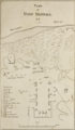
 Fort Tilden Plan.jpg 1,000 × 502; 67 KB
-
 Fort-sanders-assault-map-1863-tn1.jpg 374 × 542; 42 KB
-
 FortHerkimer1776.gif 900 × 765; 106 KB
-
 Ft-Ruckman-Map.jpg 895 × 609; 105 KB
-
 King Site Aerial HRoe 2018.jpg 380 × 253; 117 KB
-
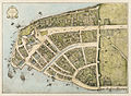
 Mannados.jpg 1,173 × 918; 592 KB
-
 Plan of Camp Baker.png 1,410 × 2,409; 2.86 MB
-
 Plan of Fort Abercrombie.png 1,455 × 2,420; 3.44 MB
-
 Plan of Fort Benton.png 1,406 × 2,414; 2.75 MB
-
 Plan of Fort Bridger.png 1,402 × 2,412; 3.62 MB
-
 Plan of Fort Buford.png 1,464 × 2,449; 3.54 MB
-
 Plan of Fort D. A. Russell.png 1,386 × 2,366; 2.95 MB
-
 Plan of Fort Dodge.png 1,397 × 2,394; 2.99 MB
-
 Plan of Fort Ellis.png 1,415 × 2,404; 2.99 MB
-
 Plan of Fort Fetterman.png 1,410 × 2,409; 3.26 MB
-
 Plan of Fort Fred Steele.png 1,424 × 2,400; 3.32 MB
-
 Plan of Fort Harker.png 1,331 × 2,446; 2.58 MB
-
 Plan of Fort Laramie.png 1,400 × 2,414; 3.38 MB
-
 Plan of Fort Leavenworth.png 1,410 × 2,433; 3.57 MB
-
 Plan of Fort Pembina.png 1,410 × 2,399; 2.76 MB
-
 Plan of Fort Randall.png 1,396 × 2,400; 3.66 MB
-
 Plan of Fort Rice.png 1,396 × 2,404; 3.44 MB
-
 Plan of Fort Riley.png 1,415 × 2,433; 3 MB
-
 Plan of Fort Ripley.png 1,430 × 2,423; 3.46 MB
-
 Plan of Fort Sanders.png 1,391 × 2,399; 2.87 MB
-
 Plan of Fort Shaw.png 1,400 × 2,390; 2.66 MB
-
 Plan of Fort Snelling.png 1,394 × 2,420; 2.98 MB
-
 Plan of Fort Stevenson.png 1,423 × 2,399; 1.48 MB
-
 Plan of Fort Sully.png 1,401 × 2,395; 3.03 MB
-
 Plan of Fort Totten.png 1,419 × 2,404; 3.17 MB
-
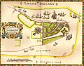
 Redraft of the Castello Plan New Amsterdam in 1660 by John Wolcott Adams.jpg 5,776 × 4,197; 4.58 MB
.jpg)
.jpg)

_-_NARA_-_305788.jpg)

.jpg)


