Category:Pipeline maps of the United States
Jump to navigation
Jump to search
Media in category "Pipeline maps of the United States"
The following 14 files are in this category, out of 14 total.
-
 8 Inch Pipe Line from Arlington, Texas to Standish, Missouri - NARA - 76028701.jpg 10,690 × 5,248; 12.89 MB
-
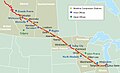
 Alberta Clipper pipeline.png 2,500 × 1,500; 305 KB
-
 AtlanticCoastPipeline map.pdf 1,922 × 1,304; 351 KB
-
 Diamondpipelinemap.png 502 × 227; 39 KB
-
 Map US Natural Gas.gif 676 × 446; 47 KB
-
 Map us ng pipelines.gif 702 × 456; 59 KB
-
 Mountian Valley Pipeline.png 580 × 492; 342 KB
-
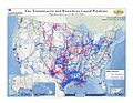 NPMS Gas Transmission and Hazardous Liquid Pipelines in the United States.jpg 1,056 × 816; 848 KB
-
 Ruby Pipeline Natural Gas Pipeline.jpeg 625 × 290; 37 KB
-

-
 State-of-Alaska-Map.png 600 × 576; 36 KB
-
 System-map.jpg 1,029 × 622; 234 KB
-
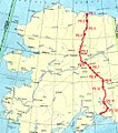 Trans alaska international.jpg 958 × 1,083; 589 KB
-
 US Natural Gas Pipelines 2000.jpg 960 × 720; 165 KB


.png)


