Category:Pierre Shale in South Dakota
Jump to navigation
Jump to search
Subcategories
This category has the following 3 subcategories, out of 3 total.
Media in category "Pierre Shale in South Dakota"
The following 7 files are in this category, out of 7 total.
-

-
 NPS badlands-geologic-map-west.jpg 3,320 × 2,280; 1.66 MB
-
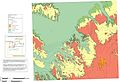
 NPS wind-cave-geologic-map.jpg 3,232 × 3,720; 1.85 MB
-
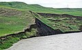 Pierre Shale & slump (Cheyenne River, near Wasta, South Dakota, USA) 1 (32870179138).jpg 4,000 × 2,451; 5.82 MB
-
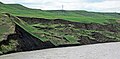 Pierre Shale & slump (Cheyenne River, near Wasta, South Dakota, USA) 2 (32870179558).jpg 4,000 × 1,959; 5.32 MB
-

-

_(Pierre_Shale,_Upper_Cretaceous;_Meade_County,_South_Dakota,_USA).jpg)


_1_(32870179138).jpg)
_2_(32870179558).jpg)
_(roadcut_ENE_of_Wasta,_South_Dakota,_USA)_1_(46020773834).jpg)
_(roadcut_ENE_of_Wasta,_South_Dakota,_USA)_2_(31803912577).jpg)