Category:Pianta di Roma Tempesta (1593)
Jump to navigation
Jump to search
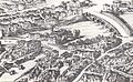
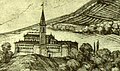
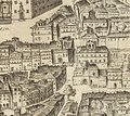
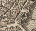
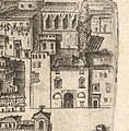
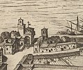
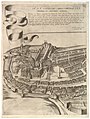
English: Plan or aerial view of the city of Rome by Antonio Tempesta, taken from the north-west. The map shows Rome in its late sixteenth-century condition. The map was first printed in 1593.
Subcategories
This category has only the following subcategory.
Media in category "Pianta di Roma Tempesta (1593)"
The following 37 files are in this category, out of 37 total.
-
 Ausschnitt aus Tempesta (Merian) 1606.jpg 1,671 × 1,359; 1.53 MB
-
 Campo Santo Teutonico 1593.jpg 623 × 468; 65 KB
-
 Churches in Borgo (detail) by Antonio Tempesta (1593).jpg 364 × 430; 96 KB
-
 Map of Rome by Antonio Tempesta - Detail.jpg 661 × 702; 453 KB
-
 Mappa di Roma antica , 1593 - Archivio Accademia delle Scienze Torino, Millon 66 28 131.jpg 3,876 × 4,942; 3.31 MB
-
 RomaTempesta.jpg 761 × 467; 86 KB
-
 San Bartolomeo in Insula by Antonio Tempesta (1593).jpg 264 × 401; 61 KB
-
 San Nicola in Arcione in the Map of Rome by Antonio Tempesta (1593).jpg 1,024 × 482; 652 KB
-
 San Pietro in Montorio by Antonio Tempesta (1593).jpg 364 × 214; 60 KB
-
 Santa Maria in Trastevere by Antonio Tempesta (1593).jpg 364 × 214; 60 KB
-
 Tempesta 1593 (1645) — Santa Lucia alle Botteghe Oscure.jpg 477 × 425; 157 KB
-
 Tempesta 1593 Oratorio della Santissima Trinità dei Pellegrini.jpg 1,121 × 948; 1.2 MB
-
 Tempesta 1593 San Biagio in Mercatello.jpg 434 × 295; 153 KB
-
 Tempesta 1593 San Francesco d'Assisi a Ponte Sisto.jpg 1,009 × 797; 919 KB
-
 Tempesta 1593 San Giovanni Decollato a Ponte Sant'Angelo.jpg 588 × 579; 412 KB
-
 Tempesta 1593 San Giuliano all'Esquilino.jpg 413 × 343; 106 KB
-
 Tempesta 1593 San Lorenzo in Damaso.jpg 622 × 509; 385 KB
-
 Tempesta 1593 San Macuto.jpg 595 × 586; 422 KB
-
 Tempesta 1593 San Matteo in Merulana.jpg 768 × 754; 538 KB
-
 Tempesta 1593 San Sisto Vecchio.jpg 753 × 433; 391 KB
-
 Tempesta 1593 Sant'Angelo al Corridoio.jpg 431 × 296; 159 KB
-
 Tempesta 1593 Sant'Anna de Marmorata.jpg 754 × 434; 391 KB
-
 Tempesta 1593 Sant'Apollinare.jpg 349 × 356; 123 KB
-
 Tempesta 1593 Sant'Eligio dei Ferrari.jpg 725 × 540; 460 KB
-
 Tempesta 1593 Santa Maria dell'Orazione e Morte.jpg 1,226 × 789; 1.07 MB
-
 Tempesta 1593 Santa Maria in Cappella.jpg 476 × 434; 226 KB
-
 Tempesta 1593 Santa Maria in Monserrato.jpg 793 × 547; 523 KB
-
 Tempesta 1593 Santa Maria Maddalena delle Convertite.jpg 560 × 432; 224 KB
-
 Tempesta 1593 Santi Faustino e Giovita.jpg 482 × 446; 246 KB
-
 Tempesta 1593 – Monastero di Tor de' Specchi.jpg 1,471 × 646; 1.12 MB
-
 Tempesta 1593 – Santa Maria di Loreto.jpg 353 × 323; 143 KB
-
 Tempesta 1593 – Santa Maria in Turri (Trastevere).jpg 636 × 542; 363 KB
-
 Tempesta 1593, De Rossi 1645.jpg 2,812 × 3,729; 3.87 MB
-
 Veduta di Roma, 1593 - Archivio Accademia delle Scienze Torino, Millon 66 28 125.jpg 3,635 × 4,668; 3.41 MB
-

-

-

_1606.jpg)

_by_Antonio_Tempesta_(1593).jpg)


.jpg)
.jpg)
.jpg)
.jpg)
_%E2%80%94_Santa_Lucia_alle_Botteghe_Oscure.jpg)


.jpg)


