Category:Phantom Creek
Jump to navigation
Jump to search
natural watercourse in Coconino County, Arizona, United States of America | |||||
| Upload media | |||||
| Instance of | |||||
|---|---|---|---|---|---|
| Location | Coconino County, Arizona | ||||
 | |||||
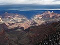
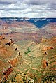
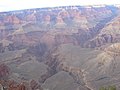
A west tributary to Bright Angel Creek (canyon). The outfall with Bright Angel Creek is at Phantom Ranch, just north of Granite Gorge, on the Colorado River, Grand Canyon.
The headwaters are adjacent Tiyo Point on the Kaibab Plateau, and Widforss Point. Phantom Canyon’s major tributary is Haunted Canyon, and the watershed drains from Widforss Point and Manu Temple, just east of Tiyo Point.
Subcategories
This category has the following 4 subcategories, out of 4 total.
B
J
S
T
Media in category "Phantom Creek"
The following 20 files are in this category, out of 20 total.
-

-

-
 Arizona. LOC 99446124-2.jpg 6,471 × 8,018; 12.08 MB
-
 Arizona. LOC 99446126-2.jpg 5,014 × 6,252; 6.24 MB
-
 Bright Angel Creek canyon from Rim Trail in Grand Canyon NP.jpeg 1,000 × 663; 100 KB
-
 Bright Angel Trailhead03.jpg 2,520 × 1,680; 2.8 MB
-
 Grand Canyon (26554597262).jpg 4,608 × 3,456; 3.04 MB
-
 Grand Canyon cloud.jpg 603 × 900; 211 KB
-
 Grand Canyon Vincent Bloch.jpg 2,560 × 1,920; 3.28 MB
-
 Grand canyon yavapal point 2010.JPG 4,209 × 2,744; 4.55 MB
-
 GrandCanyon2007a.JPG 2,816 × 2,112; 1.27 MB
-
 GrandNP.jpg 2,288 × 1,712; 873 KB
-
 ImprovedMatherPoint.jpg 3,843 × 3,264; 2.16 MB
-
 Kanion Kolorado2004.jpg 1,600 × 1,200; 229 KB
-
 NPS grand-canyon-south-rim-map.pdf 3,258 × 1,472; 13.71 MB
-
 Phantom Creek - Flickr - brewbooks.jpg 3,264 × 2,448; 5.39 MB
-
 Phantom Fault - Flickr - brewbooks (2).jpg 3,193 × 634; 792 KB
-
 Phantom Fault - Flickr - brewbooks.jpg 3,264 × 2,448; 2.65 MB
-
 South Kaibab Trail from Yaki Point, Grand Canyon (6633031507).jpg 1,600 × 1,063; 759 KB
-
 Walking through the Basement Rock - Flickr - brewbooks.jpg 3,264 × 2,448; 4.06 MB
.jpg)
.jpg)


.jpg)


.jpg)

.jpg)