Category:Pfarrkirche St. Nikolaus (Flühstrasse 38, Hofstetten SO)
Jump to navigation
Jump to search
| Object location | | View all coordinates using: OpenStreetMap |
|---|
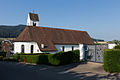
church building in Hofstetten-Flüh in the canton of Solothurn, Switzerland  | |||||
| Upload media | |||||
| Instance of | |||||
|---|---|---|---|---|---|
| Part of | |||||
| Location | Hofstetten-Flüh, Dorneck District, Dorneck-Thierstein, Solothurn, Switzerland | ||||
| Street address |
| ||||
| Heritage designation | |||||
 | |||||
Media in category "Pfarrkirche St. Nikolaus (Flühstrasse 38, Hofstetten SO)"
The following 2 files are in this category, out of 2 total.
-
 2014-Hofstetten-Kirche.jpg 1,500 × 1,000; 1.27 MB
-
 Hofstetten2.jpg 2,448 × 3,264; 1.79 MB
