Category:Pfarrkirche Plaue (Havel)
Jump to navigation
Jump to search
| Object location | | View all coordinates using: OpenStreetMap |
|---|
church building in Brandenburg state, Germany  | |||||
| Upload media | |||||
| Instance of | |||||
|---|---|---|---|---|---|
| Location | Plaue, Brandenburg an der Havel, Brandenburg, Germany | ||||
| Heritage designation | |||||
 | |||||
This is the category of the Brandenburger Baudenkmal (cultural heritage monument) with the ID 09145464 (Wikidata)
|
Media in category "Pfarrkirche Plaue (Havel)"
The following 17 files are in this category, out of 17 total.
-
 Arnim-Epitaph in Plaue.JPG 2,592 × 4,608; 2 MB
-
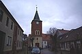
 BRB-Plau951Kirchturm.JPG 3,000 × 4,000; 4.82 MB
-
 BRB-Plau952Schiff nach SW.JPG 3,000 × 4,000; 4.69 MB
-
 BRB-Plau954Kirchenschiff v N.JPG 4,000 × 3,000; 4.84 MB
-
 BRB-Plau955KIrchenschiff v S.JPG 4,000 × 3,000; 5.19 MB
-
 Engelstor.jpg 4,896 × 3,672; 7.97 MB
-
 FWHvonKoenigsmarck.JPG 2,592 × 4,608; 1.66 MB
-
 Grabmal für Lily Gräfin von Koenigsmarck Ausschnitt Plaue Brandenburg.jpg 4,928 × 3,264; 9.75 MB
-
 Grabmal für Lily Gräfin von Koenigsmarck Plaue Brandenburg.jpg 4,928 × 3,264; 11.41 MB
-
 Grabmal Lily Gräfin von Koenigsmarck (Brandenburg an der Havel).jpg 2,509 × 1,884; 1.2 MB
-
 Grabmal von Lily Gräfin von Koenigsmarck.jpg 3,672 × 4,896; 9.19 MB
-
 Grabplatte Leonhard von Arnim.jpg 3,357 × 4,467; 5.72 MB
-
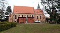 Kirche in Plaue (Brandenburg).JPG 4,608 × 2,592; 2.93 MB
-
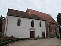 Kirche plaue.JPG 2,721 × 2,042; 874 KB
-
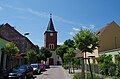 Kirchstraße Kirche Plaue Brandenburg.jpg 4,928 × 3,264; 9.67 MB
-
 Luftbild Pfarrkirche Plaue.jpg 3,351 × 2,509; 3.52 MB
-
 Plaue Turm.jpg 3,872 × 2,592; 6.54 MB


.jpg)


.JPG)


Categories:
- Churches in Brandenburg an der Havel
- Cultural heritage monuments in Brandenburg an der Havel
- Plaue (Havel)
- Churches in Kirchenkreis Mittelmark-Brandenburg
- Lutheran churches in Brandenburg
- Romanesque brick churches in Brandenburg
- Brick Gothic hall churches in Brandenburg
- 13th-century churches in Brandenburg