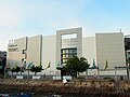
Category:Peng Chau Municipal Services Building
Jump to navigation
Jump to search
| Object location | | View all coordinates using: OpenStreetMap |
|---|
| Upload media | |||||
| Instance of | |||||
|---|---|---|---|---|---|
| Location | Hong Kong, PRC | ||||
 | |||||
中文:坪洲市政大廈
Media in category "Peng Chau Municipal Services Building"
The following 8 files are in this category, out of 8 total.
-
 Building of peng chau.jpg 3,648 × 2,736; 2.05 MB
-
 Peng Chau from Nam Wan promenade.jpg 4,032 × 3,024; 5.85 MB
-
 Peng Chau Island Hong Kong - panoramio (6).jpg 2,560 × 1,920; 4.05 MB
-
 Peng Chau Municipal Services Building (Hong Kong).jpg 4,592 × 3,056; 3.51 MB
-
 Peng Chau Public Library (Hong Kong).jpg 4,592 × 3,056; 3.59 MB
-
 Peng Chau Public Pier (Hong Kong).jpg 4,506 × 2,998; 3.89 MB
-
 Ping Isand 1.JPG 1,600 × 1,200; 584 KB
-
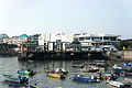
 Waterfront shopping area, Peng Chau, Hong Kong.jpg 3,792 × 2,888; 7.39 MB


.jpg)
.jpg)
.jpg)
.jpg)

