Category:Peng Chau Government Building
Jump to navigation
Jump to search
| Object location | | View all coordinates using: OpenStreetMap |
|---|
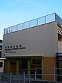
中文:坪洲政府合署
| Upload media | |||||
| Location | Hong Kong, PRC | ||||
|---|---|---|---|---|---|
 | |||||
Media in category "Peng Chau Government Building"
The following 3 files are in this category, out of 3 total.
-
 HK PengChauGovernmentBuilding.JPG 2,848 × 2,136; 1.37 MB
-
 Peng Chau from Nam Wan promenade.jpg 4,032 × 3,024; 5.85 MB
-
 Peng chau gov.jpg 2,736 × 3,648; 2.02 MB


