Category:Pendleton County, Kentucky
Jump to navigation
Jump to search
Counties of Kentucky: Adair · Allen · Anderson · Ballard · Barren · Bath · Bell · Boone · Bourbon · Boyd · Boyle · Bracken · Breathitt · Breckinridge · Bullitt · Butler · Caldwell · Calloway · Campbell · Carlisle · Carroll · Carter · Casey · Christian · Clark · Clay · Clinton · Crittenden · Cumberland · Daviess · Edmonson · Elliott · Estill · Fayette · Fleming · Floyd · Franklin · Fulton · Gallatin · Garrard · Grant · Graves · Grayson · Green · Greenup · Hancock · Hardin · Harlan · Harrison · Hart · Henderson · Henry · Hickman · Hopkins · Jackson · Jefferson · Jessamine · Johnson · Kenton · Knott · Knox · LaRue · Laurel · Lawrence · Lee · Leslie · Letcher · Lewis · Lincoln · Livingston · Logan · Lyon · Madison · Magoffin · Marion · Marshall · Martin · Mason · McCracken · McCreary · McLean · Meade · Menifee · Mercer · Metcalfe · Monroe · Montgomery · Morgan · Muhlenberg · Nelson · Nicholas · Ohio · Oldham · Owen · Owsley · Pendleton · Perry · Pike · Powell · Pulaski · Robertson · Rockcastle · Rowan · Russell · Scott · Shelby · Simpson · Spencer · Taylor · Todd · Trigg · Trimble · Union · Warren · Washington · Wayne · Webster · Whitley · Wolfe · Woodford
county in Kentucky, United States   | |||||
| Upload media | |||||
| Instance of | |||||
|---|---|---|---|---|---|
| Part of | |||||
| Named after | |||||
| Location | Kentucky | ||||
| Capital | |||||
| Inception |
| ||||
| Population |
| ||||
| Area |
| ||||
| Different from | |||||
| official website | |||||
 | |||||
Subcategories
This category has the following 7 subcategories, out of 7 total.
Media in category "Pendleton County, Kentucky"
The following 12 files are in this category, out of 12 total.
-
 Bell, Alice, family outside of home damaged by a storm - NARA - 281014.jpg 3,000 × 1,780; 1.24 MB
-
 Booth, Preston, family in doorway of home - NARA - 281009.jpg 3,000 × 1,773; 1.61 MB
-
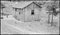
 Davis, G.F., home - NARA - 281023.jpg 3,000 × 1,763; 1.33 MB
-
 FryerHouse2013.JPG 2,048 × 1,536; 745 KB
-
-

-

-
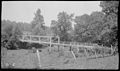
 Oholoma School - NARA - 280126.jpg 3,000 × 1,789; 1.5 MB
-
 Oholoma School - NARA - 280126.tif 3,000 × 1,789; 5.12 MB
-
 USA Pendleton County, Kentucky age pyramid.svg 520 × 600; 8 KB
-
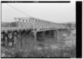
 Wolfert Creek Bridge - NARA - 280114.jpg 3,000 × 1,769; 1.29 MB
-
 Wolfert Creek Bridge - NARA - 280114.tif 3,000 × 1,769; 5.06 MB


