Category:Paro Taktsang
Jump to navigation
Jump to search
| Object location | | View all coordinates using: OpenStreetMap |
|---|
temple complex in Bhutan  | |||||
| Upload media | |||||
| Instance of | |||||
|---|---|---|---|---|---|
| Location | Paro, Wangchang Gewog, Paro District, Bhutan | ||||
| Inception |
| ||||
| Religion or worldview |
| ||||
 | |||||
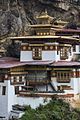
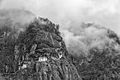
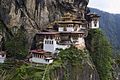
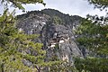
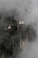
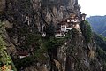
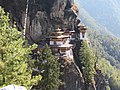
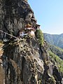
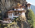
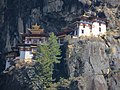
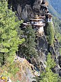
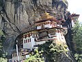
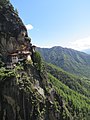
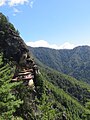
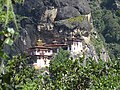
- Paro Taktsang — 17th-century Buddhist monastery in the Paro District of Bhutan.
Subcategories
This category has the following 3 subcategories, out of 3 total.
Media in category "Paro Taktsang"
The following 200 files are in this category, out of 342 total.
(previous page) (next page)-
 Bhutan (8026022737).jpg 853 × 1,280; 262 KB
-
 Bhutan (8026022926).jpg 853 × 1,280; 223 KB
-
 Bhutan (8026023059).jpg 853 × 1,280; 301 KB
-
 Bhutan (8026023135).jpg 853 × 1,280; 273 KB
-
 Bhutan (8026023249).jpg 907 × 1,280; 328 KB
-
 Bhutan (8026023342).jpg 1,280 × 853; 221 KB
-
 Bhutan (8026023384).jpg 1,280 × 853; 180 KB
-
 Bhutan (8026023699).jpg 1,280 × 853; 314 KB
-
 Bhutan (8026023920).jpg 1,280 × 853; 296 KB
-
 Bhutan (8026023992).jpg 1,280 × 853; 284 KB
-
 Bhutan (8026024152).jpg 853 × 1,280; 307 KB
-
 Bhutan (8026024700).jpg 1,280 × 853; 333 KB
-
 Bhutan - Taktsang Monastery "Tiger´s nest" (6581764759).jpg 3,455 × 2,764; 7.21 MB
-
 Bhutan - Taktsang Monastery "Tiger´s nest" (6581774939).jpg 3,192 × 2,600; 7.48 MB
-
 Bhutan okt-nov 2010. LW.jpg 4,288 × 2,848; 6.66 MB
-
 Bhutan okt-nov 2010.jpg 4,288 × 2,848; 5.82 MB
-
 Bhutan-Paro-114-Taktshang-Tigernest in Wolken-gje.jpg 3,456 × 5,184; 2.8 MB
-
 Bhutan-Paro-116-Taktshang-Tigernest-gje.jpg 5,184 × 3,456; 3.18 MB
-
 Bhutan-Paro-128-Taktshang-Tigernest-gje.jpg 3,456 × 5,184; 3.73 MB
-
 Bhutan-Paro-130-Taktshang-Tigernest-gje.jpg 5,184 × 3,456; 3.99 MB
-
 Bhutan-Paro-132-Taktshang-Tigernest-gje.jpg 5,184 × 3,456; 4.1 MB
-
 Bhutan-Paro-136-Taktshang-Tigernest-gje.jpg 5,184 × 3,456; 11.86 MB
-
 Bhutan-Paro-138-Taktshang-Tigernest-gje.jpg 3,456 × 5,184; 4.86 MB
-
 Bhutan-Paro-140-Taktshang-Tigernest-gje.jpg 5,184 × 3,456; 3.19 MB
-
 Bhutan-Paro-142-Abstieg vom Taktshang-Tigernest-gje.jpg 5,184 × 3,456; 5.02 MB
-
 Bhutan1980-27 hg.jpg 10,474 × 7,002; 4.41 MB
-
 Building and prayer flags.jpg 1,280 × 800; 1.05 MB
-
 Clouds rise up to the Tiger's Nest.jpg 1,280 × 800; 999 KB
-
 Far pavilion.jpg 1,280 × 800; 1.05 MB
-
 First glimpse of Taktshang.jpg 1,939 × 2,029; 4.73 MB
-
 Greenery around (Paro Taktsang).jpg 1,280 × 800; 1.57 MB
-
 Hole in the wall shrine.jpg 853 × 1,280; 1.38 MB
-
 Jorn Bjorn Augestad in Bhutan.jpg 2,048 × 1,536; 699 KB
-
 Lichen (Paro Taktsang).jpg 853 × 1,280; 1.58 MB
-
 Little shrine.jpg 1,280 × 800; 1.21 MB
-
 On a cliff.jpg 853 × 1,280; 1.74 MB
-
 Paro - Taktsang Kloster 3070 m.ü.NN. .JPG 4,780 × 3,528; 4.01 MB
-
 Paro - Taktsang Kloster 3070 m.ü.NN. 02.JPG 5,472 × 3,080; 4.19 MB
-
 Paro 2-10 (8214228046).jpg 2,888 × 2,550; 2.68 MB
-
 Paro 2-12 (8214231386).jpg 4,000 × 3,000; 4.06 MB
-
 Paro 2-14 (8214235110).jpg 4,000 × 3,000; 4.95 MB
-
 Paro 2-16 (8214238902).jpg 3,000 × 4,000; 3.45 MB
-
 Paro 2-17 (8213206533).jpg 3,000 × 4,000; 5.14 MB
-
 Paro 2-18 (8214268604).jpg 3,773 × 2,889; 4.24 MB
-
 Paro 2-20 (8214270924).jpg 3,000 × 4,000; 3.21 MB
-
 Paro 2-22 (8214274258).jpg 4,000 × 3,000; 3.55 MB
-
 Paro 2-28 (8213209943).jpg 4,000 × 3,000; 3.09 MB
-
 Paro 2-31 (8213230729).jpg 3,000 × 4,000; 3.39 MB
-
 Paro 2-32 (8214320186).jpg 4,000 × 3,000; 4.34 MB
-
 Paro 2-33 (8213233907).jpg 2,611 × 2,086; 1.9 MB
-
 Paro 2-40 (8213315717).jpg 4,000 × 3,000; 4.6 MB
-
 Paro 2-54 (8214420634).jpg 4,000 × 3,000; 5.18 MB
-
 Paro 2-55 (8214423184).jpg 3,000 × 4,000; 5.05 MB
-
 Paro 2-56 (8213337603).jpg 3,000 × 4,000; 3.89 MB
-
 Paro Taktsang - Flickr - babasteve.jpg 1,094 × 720; 146 KB
-
 Paro Taktsang or Tiger Nest of Bhutan.jpg 4,608 × 3,072; 3.57 MB
-
 Paro Taktsang, Bhutan (49693919598).jpg 2,581 × 3,872; 10.39 MB
-

-

-

-

-

-

-

-

-

-

-

-
-

-

-

-

-

-

-

-

-

-

-

-

-

-

-

-

-

-
-

-

-

-

-

-

-

-

-

-
-

-

-

-

-

-

-

-

-

-

-

-

-

-

-

-

-

-
-

-

-

-

-

-

-

-

-

-

-

-

-

-

-

-

-

-

-

-

-

-

-

-

-

-

-

-

-

-

-

-

-

-

-

-

-

-

-

-

-

-
-

-

-

-

-

-

-

-

-

-

-

-

-

-

-

-

-
-

-

-

-

-

-

-

-

-

-

-

-

-

-

-

-
-

-

-

-

-

-

-

-

-

-

.jpg)
.jpg)
.jpg)
.jpg)
.jpg)
.jpg)
.jpg)
.jpg)
.jpg)
.jpg)
.jpg)
.jpg)
.jpg)
.jpg)


.jpg)


.jpg)


.jpg)
.jpg)
.jpg)
.jpg)
.jpg)
.jpg)
.jpg)
.jpg)
.jpg)
.jpg)
.jpg)
.jpg)
.jpg)
.jpg)
.jpg)
.jpg)


.jpg)
.jpg)
.jpg)
.jpg)
.jpg)
.jpg)
.jpg)
.jpg)
.jpg)
.jpg)
.jpg)
.jpg)
.jpg)
.jpg)
.jpg)
.jpg)
.jpg)
.jpg)
.jpg)
.jpg)
.jpg)
.jpg)
.jpg)
.jpg)
.jpg)
.jpg)
.jpg)
.jpg)
.jpg)
.jpg)
.jpg)
.jpg)
.jpg)
.jpg)
.jpg)
.jpg)
.jpg)
.jpg)
.jpg)
.jpg)
.jpg)
.jpg)
.jpg)
.jpg)
.jpg)
.jpg)
.jpg)
.jpg)
.jpg)
.jpg)
.jpg)
.jpg)
.jpg)
.jpg)
.jpg)
.jpg)
.jpg)
.jpg)
.jpg)
.jpg)
.jpg)
.jpg)
.jpg)
.jpg)
.jpg)
.jpg)
.jpg)
.jpg)
.jpg)
.jpg)
.jpg)
.jpg)
.jpg)
.jpg)
.jpg)
.jpg)
.jpg)
.jpg)
.jpg)
.jpg)
.jpg)
.jpg)
.jpg)
.jpg)
.jpg)
.jpg)
.jpg)
.jpg)
.jpg)
.jpg)
.jpg)
.jpg)
.jpg)
.jpg)
.jpg)
.jpg)
.jpg)
.jpg)
.jpg)
.jpg)
.jpg)
.jpg)
.jpg)
.jpg)
.jpg)
.jpg)
.jpg)
.jpg)
.jpg)
.jpg)
.jpg)
.jpg)
.jpg)
.jpg)
.jpg)
.jpg)
.jpg)
.jpg)
.jpg)
.jpg)
.jpg)
.jpg)
.jpg)
.jpg)
.jpg)
.jpg)
.jpg)
.jpg)
.jpg)
.jpg)
.jpg)
.jpg)
.jpg)
.jpg)
.jpg)
.jpg)
.jpg)
.jpg)
.jpg)
.jpg)
.jpg)
.jpg)
.jpg)
.jpg)