Category:Pang Ung
Jump to navigation
Jump to search
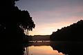
English: Pang Ung, Mae Hong Son
Pang Ung (Pang Oong) or "Pangtong2" is one of the Royal Initiative projects by HM Queen Sirikit for highland development. The place sometimes is referred to "Ruam Thai" on maps and signs. It is a Shan Minority Village where it has been developed with modern agricultural projects.
A large reservoir in Pang Ung is popular and attracts more and more visitors to come every year. Its lake view, pine leaves, beautiful mountain scenes, and hazy fog in the morning are a perfect combination for visitors who love to touch by natures. Surrounded by a verdant pine forest, the lake is beautiful in every season. Walking or Jogging along the lakeside are pleasant activities to do. There are camping areas and guesthouses around the lake. Pang Ung sometimes is called "Switzerland in Thailand". In the winter, sometimes the temperature drops to zero and create a thin film of ice covered flowers and plants.ไทย: ปางอุ๋ง อ.ปาย จังหวัดแม่ฮ่องสอน
_-_Swan_with_fog.jpg) | |||||
| Upload media | |||||
| Instance of | |||||
|---|---|---|---|---|---|
| Location | Mok Champae, Mueang Mae Hong Son, Mae Hong Son, Thailand | ||||
 | |||||
Media in category "Pang Ung"
The following 6 files are in this category, out of 6 total.
-
 Pang Ung (Pang Oong) - Corner of forest.jpg 3,264 × 2,448; 3.77 MB
-
 Pang Ung (Pang Oong) - Swan with fog.jpg 3,264 × 2,448; 3.54 MB
-
 บรรยากาศยามเช้า ณ ปางอุ๋ง.jpg 3,648 × 2,432; 1.81 MB
-
 พระอาทิตย์ขึ้น ณ ปางอุ๋ง.jpg 3,648 × 2,432; 1.28 MB
-
 เช้าตรู่ ณ ปางอุ๋ง.jpg 3,648 × 2,432; 888 KB
-
 แดดรำไร ณ ปางอุ๋ง.jpg 3,648 × 2,432; 1.03 MB
_-_Corner_of_forest.jpg)


