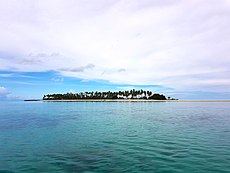
Category:Panampangan Island
Jump to navigation
Jump to search
island in Tawi-Tawi Province of Mindanao, Philippines | |||||
| Upload media | |||||
| Instance of | |||||
|---|---|---|---|---|---|
| Part of | |||||
| Location | Sapa-Sapa, Tawi-Tawi, Bangsamoro, PH | ||||
| Located in or next to body of water | |||||
| Area |
| ||||
| Elevation above sea level |
| ||||
 | |||||
Media in category "Panampangan Island"
The following 2 files are in this category, out of 2 total.
-
Panampangan Island.jpg 3,973 × 2,980; 1.33 MB
-
PanampanganIsland-aerial.jpg 2,048 × 688; 1.5 MB

