Category:Pakhuis Deventer (Amsterdam)
Jump to navigation
Jump to search
| Object location | | View all coordinates using: OpenStreetMap |
|---|
 | |||||
| Upload media | |||||
| Instance of | |||||
|---|---|---|---|---|---|
| Part of |
| ||||
| Named after | |||||
| Location | Amsterdam, North Holland, Netherlands | ||||
| Street address |
| ||||
| Located on street | |||||
| Heritage designation |
| ||||
 | |||||
|
This is a category about rijksmonument number 1045
|
| Address |
|
Media in category "Pakhuis Deventer (Amsterdam)"
The following 12 files are in this category, out of 12 total.
-

-
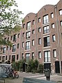
 Amsterdam - Entrepotdok - Deventer.JPG 3,056 × 4,592; 5.29 MB
-
 Dak - Amsterdam - 20011329 - RCE.jpg 1,200 × 803; 200 KB
-
 Entrepotdok - Amsterdam (63).JPG 1,536 × 2,048; 1.42 MB
-
 Entrepotdok - Amsterdam (64).JPG 1,536 × 2,048; 1.49 MB
-
 M 21 - Amsterdam - 20011300 - RCE.jpg 1,197 × 1,200; 269 KB
-
 M 24 - Amsterdam - 20011299 - RCE.jpg 1,197 × 1,200; 273 KB
-
 Overzicht 18-27 - Amsterdam - 20011301 - RCE.jpg 1,192 × 1,200; 294 KB
-
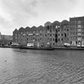
 Overzicht gevelwand, gezien vanaf de brug - Amsterdam - 20426047 - RCE.jpg 1,200 × 768; 182 KB
-
 Overzicht gevelwand, gezien vanaf de brug - Amsterdam - 20426048 - RCE.jpg 1,200 × 770; 182 KB
-
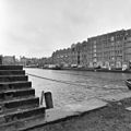
 Overzicht vanaf nr. 10 - Amsterdam - 20011298 - RCE.jpg 1,186 × 1,200; 239 KB
-
 Rm1045.JPG 2,736 × 3,648; 2.04 MB


.JPG)
.JPG)


