Category:OpenStreetMap maps of Potsdam
Jump to navigation
Jump to search
Media in category "OpenStreetMap maps of Potsdam"
The following 6 files are in this category, out of 6 total.
-
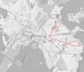 Obusnetz Potsdam 1971-1995.PNG 1,024 × 881; 770 KB
-
 Park Sanssouci.png 2,310 × 1,723; 1.34 MB
-
 Potsdam location map.png 1,087 × 1,041; 1.51 MB
-
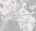 Tramnetz Potsdam.PNG 1,901 × 1,635; 2.1 MB
-
 TramsInPotsdam2012-05-19.png 8,606 × 6,202; 34.68 MB
-
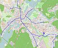 TramsInPotsdam2012.jpg 6,450 × 5,343; 6.32 MB


