Category:Oosterstraat 55 (Groningen)
Jump to navigation
Jump to search
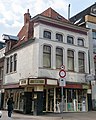
Nederlands: Oosterstraat 55 (hoek Carolieweg), Groningen, gem.mon. 102863
| Object location | | View all coordinates using: OpenStreetMap |
|---|
|
This is a category about a municipal monument in Groningen with number 102863 |
Media in category "Oosterstraat 55 (Groningen)"
The following 6 files are in this category, out of 6 total.
-
 Groningen Carolieweg 33.JPG 3,264 × 2,448; 3.84 MB
-
 Hoek Carolieweg - Groningen - 20094116 - RCE.jpg 813 × 1,200; 204 KB
-
 LG-Groningen- Oosterstraat 55 - 1.JPG 2,816 × 2,112; 1.29 MB
-
 LG-Groningen- Oosterstraat 55 - 2.JPG 2,112 × 2,816; 1.27 MB
-
 Oosterstraat 55.jpg 2,641 × 3,301; 4.97 MB
-
 Winkelhuis - Groningen - 20094111 - RCE.jpg 881 × 1,200; 220 KB


