Category:Old maps of the Kingdom of the Suebi
Jump to navigation
Jump to search
Media in category "Old maps of the Kingdom of the Suebi"
The following 15 files are in this category, out of 15 total.
-
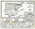 (Spruner-Menke, map 14) The Iberian peninsula 531-711.jpg 3,355 × 2,759; 2.18 MB
-
 Europa im Anfange des sechsten Jahrhunderts de Karl von Spruner.jpg 8,656 × 7,097; 13.09 MB
-
 Europe at the close of the 6th century, showing the Gothic monarchies (14780052291).jpg 2,176 × 1,392; 544 KB
-
 Europe at the death of Justinian I in 565.jpg 2,747 × 1,966; 4.19 MB
-
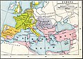
 Europe at the death of Theoderic the Great in 526.jpg 2,754 × 1,961; 3.71 MB
-
 Europe at the fall of the Western Roman Empire in 476.jpg 5,491 × 3,506; 4.35 MB
-
 Germanic roman 486 1923.jpg 2,298 × 1,730; 740 KB
-

-
 K.v. Spruner's histor. Atlas Nº 3 - Europa im Anfange des VI. Jahrhunderts.jpg 11,305 × 9,355; 15.11 MB
-
 L'Espagne 409 a 585 (Antoine Philippe Houze, 1844).jpg 5,787 × 4,502; 4.63 MB
-
 Public Schools Historical Atlas - Europe 476-493.jpg 1,579 × 1,239; 610 KB
-
 Spruner-Menke Handatlas 1880 Karte 01.jpg 10,401 × 8,722; 16.44 MB
-
 Spruner-Menke Handatlas 1880 Karte 02.jpg 10,385 × 8,785; 17.91 MB
-
 Vandali.jpg 1,477 × 2,032; 2.56 MB
-
 Visigoti.jpg 912 × 1,251; 990 KB
_The_Iberian_peninsula_531-711.jpg)

.jpg)


.jpg)


