Category:Old maps of Zaltbommel
Jump to navigation
Jump to search
Media in category "Old maps of Zaltbommel"
The following 6 files are in this category, out of 6 total.
-

-
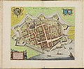 Atlas de Wit 1698-pl008-Zaltbommel-KB PPN 145205088.jpg 2,000 × 1,644; 1.74 MB
-
 Lambert-van-den-Bos-Lieuwe-van-Aitzema-Historien-onses-tyds MGG 0404.tif 4,121 × 3,556; 41.96 MB
-
 Plattegrond der stad tijdens beleg van 1599 - Zaltbommel - 20219489 - RCE.jpg 1,200 × 919; 334 KB
-
 Plattegrond van Zaltbommel, 1550 - Nederland - 20407463 - RCE.jpg 1,200 × 891; 306 KB
-
 Zaltbommel, Gemeenteatlas van Nederland.jpg 2,172 × 1,652; 4.43 MB


