Category:Old maps of Siena
Jump to navigation
Jump to search
Subcategories
This category has only the following subcategory.
M
Media in category "Old maps of Siena"
The following 19 files are in this category, out of 19 total.
-
 "Territorio di Siena et ducato di Castro" (22228082746).jpg 4,014 × 3,084; 2.51 MB
-
 Atlas Ortelius KB PPN369376781-069av-069br.jpg 3,000 × 2,194; 4.49 MB
-
 UBBasel Map Siena 1600 Kartenslg Mappe 97-25a.tif 9,813 × 6,423, 2 pages; 180.35 MB
-

-
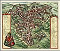 Map of Siena by Matheus Merian.jpg 1,403 × 1,200; 2.37 MB
-
 Sena (BM 1898,0725.8.1469).jpg 2,500 × 2,103; 1.76 MB
-
 Rogissart, Alexand de – Delices de l'Italie, 1709 – BEIC 8970907 Siena.jpg 1,256 × 1,014; 347 KB
-
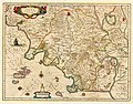 Blaeu - Territorio di Siena et Ducato di Castro.jpg 1,667 × 1,300; 1.15 MB
-
 Carte médiévale des bottini de Sienne.jpg 3,107 × 1,798; 1.53 MB
-

-
 Guide to Italy and Sicily (1911) (14579357280).jpg 2,832 × 3,980; 1.82 MB
-
-

-
 Porti della Repubblica di Siena.png 1,237 × 823; 34 KB
-
 Repubblica di Siena e Principato di Piombino tra XV e XVI secolo.png 1,230 × 869; 198 KB
-
 REPUBBLICA DI SIENA GIF.gif 1,000 × 1,111; 592 KB
-
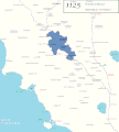
 Republica siena 1494.jpg 486 × 467; 127 KB
-
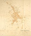
 Siena - 29-43.jpg 3,724 × 4,984; 3.56 MB
-
 Vallardi - Siena.jpg 4,034 × 6,436; 12.73 MB
.jpg)

_by_Abraham_Ortelius.jpeg)

.jpg)


_(14579357280).jpg)
_(14590733658).jpg)
_(14579261019).jpg)


