Category:Old maps of Paris 6e arrondissement
Jump to navigation
Jump to search
|
Paris 1 • 2 • 3 • 4 • 5 • 6 • 7 • 8 • 9 • 10 • 11 • 12 • 13 • 14 • 15 • 16 • 17 • 18 • 19 • 20 |
| NO WIKIDATA ID FOUND! Search for Old maps of Paris 6e arrondissement on Wikidata | |
| Upload media |
Subcategories
This category has the following 2 subcategories, out of 2 total.
Media in category "Old maps of Paris 6e arrondissement"
The following 17 files are in this category, out of 17 total.
-

-

-
 Atlas souterrain de la ville de Paris - 05. Tableau d'assemblage - BHVP.jpg 4,737 × 3,976; 2.43 MB
-
 Atlas souterrain de la ville de Paris - 14. Coupes des carrières du Luxembourg - BHVP.jpg 5,856 × 3,571; 1.95 MB
-
 Esplanade des Invalides - Rez-de-chaussée.jpg 4,254 × 3,929; 7.36 MB
-
 Karta över Paris indelat i 20 distrikt, tryckt 1763 - Skoklosters slott - 86167.tif 3,804 × 2,498; 17.81 MB
-
 Kartbok över Paris indelat i 20 distrikt, tryckt 1763 - Skoklosters slott - 86169.tif 4,176 × 2,572; 21.35 MB
-
 Paris 5e & 6e arrondissement - Eugène Andriveau-Goujon.jpg 5,316 × 3,750; 7.85 MB
-
 Paris 6e arrondissement - Eugène Andriveau-Goujon.jpg 2,808 × 2,938; 3.79 MB
-
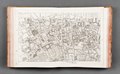
 Paris-atlas by Fernand Bournon - 18. 6e arrondissement - David Rumsey.jpg 4,599 × 5,961; 25.15 MB
-

-

-

-
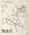
 Petit atlas pittoresque 38 - 10e arrondissement, n° 37, quartier de la Monnaie - BHVP.jpg 3,781 × 3,171; 2.59 MB
-
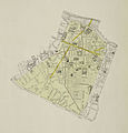
 Petit atlas pittoresque 42 - 11e arrondissement, n° 41, quartier du Luxembourg - BHVP.jpg 3,261 × 3,996; 2.18 MB
-

-
 St-Germain des prés plan 1723.jpg 1,052 × 778; 340 KB


