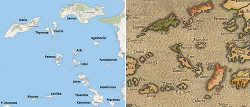
English: a series of old maps with a copying error tradition by 15th-to-17th-century cartographers. The upper center of the right map (1584 by Ortelius) shows several errors typical for these maps: Fourni is placed correctly between Samos and Icaria, but is accompanied by Lipso (Lipsi) and the (fictional?) islands of Tragia and Crusia/Cursia. Arki is left out. In the place of Arki and Lipsi, there is the (fictional?) Mandria island resembling Agathonisi; but "Gatonisi" is also the twin-island of "Fermaco" (Farmakonisi) which has wandered north. A third Agathonisi is placed in the spot of the real Farmakonisi. Patmos, Leros and Kalymnos are too closely aligned.
Subcategories
This category has the following 2 subcategories, out of 2 total.

 Liber Insularum Cycladum (Arundel MS 93.art.7, f.148r).jpeg 5,458 × 7,914; 53.04 MB
 (Lipso e Forni) - Sonetti Bartolommeo Dalli - 1485.jpg 1,106 × 1,500; 331 KB
 Lipsi and Arki RMG F1636.tiff 4,911 × 7,191; 101.04 MB
 "Dipso, Crusia e gli forni" (23309866841).jpg 3,311 × 4,626; 1.06 MB
 Map of Fournoi and Leipsoi islands - Bordone Benedetto - 1547.jpg 800 × 461; 144 KB
 1578 map of Mare Myrtoo by Cornelis de Jode.jpg 2,568 × 1,990; 1.31 MB
 OSM2023-Ortelius1584.png 1,972 × 844; 2.41 MB
 Mare Myrtoum by Lauremberg (1650s map detail).tif 2,196 × 1,702; 10.69 MB
 Mare Myrtoum by Lauremberg (1654 map detail).jpeg 1,829 × 1,484; 781 KB
 Dipso, Crusia, Forni - Boschini Marco - 1658.jpg 525 × 800; 181 KB
 Dipso, Crusia, Forni - Marco Boschini - btv1b530117674 (1 of 2).jpg 1,654 × 2,579; 622 KB
 Mare di Mandria by Giacomo Cantelli da Vignola (1685 map detail).jpg 1,120 × 932; 189 KB
 Crusia, Lipso, Tragia, Fornoli - Piacenza Francesco - 1688.jpg 1,011 × 1,500; 712 KB
 Mandria - Piacenza Francesco - 1688.jpg 1,047 × 1,500; 565 KB
 Mare di Mandria in Atlante Veneto (1690s map detail).jpg 1,082 × 880; 147 KB
 Isla Mandria in a 1703 map detail, by Olfert Dapper.jpg 396 × 347; 177 KB
.jpeg)
_-_Sonetti_Bartolommeo_Dalli_-_1485.jpg)
.jpg)
.jpg)


.jpeg)

.jpg)
.jpg)


.jpg)
