Category:Old maps of Delaware County, Pennsylvania
Jump to navigation
Jump to search
Counties of Pennsylvania : Adams · Allegheny · Armstrong · Beaver · Bedford · Berks · Blair · Bradford · Bucks · Butler · Cambria · Cameron · Carbon · Centre · Chester · Clarion · Clearfield · Clinton · Columbia · Crawford · Cumberland · Dauphin · Delaware · Elk · Erie · Fayette · Franklin · Fulton · Greene · Huntingdon · Indiana · Jefferson · Juniata · Lackawanna · Lancaster · Lawrence · Lebanon · Lehigh · Luzerne · Lycoming · McKean · Mercer · Mifflin · Monroe · Montgomery · Montour · Northampton · Northumberland · Perry · Philadelphia · Pike · Potter · Schuylkill · Snyder · Somerset · Sullivan · Susquehanna · Tioga · Union · Venango · Warren · Washington · Wayne · Westmoreland · Wyoming · York
Subcategories
This category has the following 3 subcategories, out of 3 total.
Media in category "Old maps of Delaware County, Pennsylvania"
The following 7 files are in this category, out of 7 total.
-
 1687HolmeMapProvRoad.jpg 312 × 586; 97 KB
-
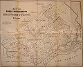
 1848 Map of Delaware Co (LOC, Ash, Kramm, Smith) (1b) JPG KH edit.jpg 685 × 961; 217 KB
-
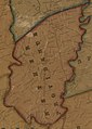
 1913 Haverford Township map.png 626 × 615; 730 KB
-
 Delaware County, Pennsylvania LOC 92683909.jpg 9,178 × 8,911; 13.09 MB
-
 Delaware County, Pennsylvania LOC 92683909.tif 9,178 × 8,911; 233.99 MB
-
 H2t.jpg 1,963 × 2,358; 3.88 MB
-

_(1b)_JPG_KH_edit.jpg)


.jpg)