Category:Old maps of Cincinnati
Jump to navigation
Jump to search
Subcategories
This category has only the following subcategory.
Media in category "Old maps of Cincinnati"
The following 33 files are in this category, out of 33 total.
-
 1846 Burroughs - Mitchell Map of Ohio - Geographicus - Ohio-m-1846.jpg 2,854 × 3,500; 2.81 MB
-

-

-
 1864 Mitchell Map of Cincinnati. Ohio - Geographicus - Cincinnati-mitchell-1864.jpg 3,596 × 3,353; 2.36 MB
-

-
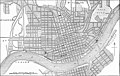
 Americana 1920 Cincinnati.jpg 2,994 × 4,032; 4.95 MB
-

-
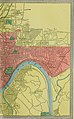
 Atlas Of The USA 1857 (Cincinatti).jpg 2,055 × 2,064; 751 KB
-
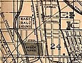 Avenue Grounds 1888 map.jpg 229 × 175; 44 KB
-
 Plan of Cincinnati and vicinity (NYPL b13663520-1510815).tiff 6,299 × 5,248; 95.24 MB
-
 Cincinnati 1870.jpg 4,344 × 4,109; 2.31 MB
-
 Cincinnati part IX embracing 11th & 19th wards. (1869).png 1,027 × 1,363; 3.05 MB
-
 Cincinnati, Ohio 1955 Yellow Book.jpg 800 × 791; 184 KB
-
 Cincinnati-aerial-view-1900 (Mill Creek).jpg 9,217 × 5,001; 24.03 MB
-
 Cincinnati-aerial-view-1900.jpg 10,000 × 6,459; 17.22 MB
-
 Cincinnati-map-1838.jpg 10,000 × 7,193; 19.12 MB
-
 Cincinnati-map-1841.jpg 6,914 × 5,566; 5.73 MB
-
 EB9 Cincinnati.jpg 2,538 × 1,616; 882 KB
-
 Fort Washington Cincinnati map.png 455 × 701; 45 KB
-
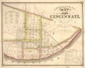
 Map of Cincinnati Wellcome L0040478.jpg 3,954 × 2,284; 3.67 MB
-

-
 Map of the city of Cincinnati LOC 2004629233.jpg 12,510 × 8,999; 18.37 MB
-
 Map of the city of Cincinnati LOC 2004629233.tif 12,510 × 8,999; 322.09 MB
-
 Map showing the military defences of Cincinnati, Covington and Newport LOC 99447487.jpg 11,519 × 8,170; 24.65 MB
-
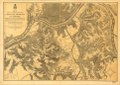 Map showing the military defences of Cincinnati, Covington and Newport LOC 99447487.tif 11,519 × 8,170; 269.25 MB
-
 The cities of Pittsburgh and Allegheny, with parts of adjacent boroughs, Pennsylvania (NYPL b20625668-5365399).tiff 7,760 × 10,328, 2 pages; 229.57 MB
-
 Panoramic view, city of Cincinnati, U.S.A. 1900. LOC 75694914 (3600px).jpg 3,600 × 2,111; 3.97 MB
-
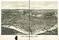 Panoramic view, city of Cincinnati, U.S.A. 1900. LOC 75694914.jpg 14,320 × 9,664; 26.61 MB
-
-

-
 Topographical map of the city of Cincinnati, from actual survey LOC 2006626028.jpg 6,914 × 5,566; 5.23 MB
-
 Topographical map of the city of Cincinnati, from actual survey LOC 2006626028.tif 6,914 × 5,566; 110.1 MB
-
 WilliamsCincinnatiDirectory 1861 page 1.png 2,493 × 2,021; 8.85 MB


.jpg)

.jpg)

.jpg)
.jpg)


.png)

.jpg)


.jpg)

_(14577005659).jpg)
_(14577016628).jpg)

