Category:North Stainley with Sleningford
Jump to navigation
Jump to search
civil parish in North Yorkshire, England, UK  | |||||
| Upload media | |||||
| Instance of | |||||
|---|---|---|---|---|---|
| Location | Harrogate, North Yorkshire, Yorkshire and the Humber, England | ||||
| official website | |||||
 | |||||
Subcategories
This category has the following 5 subcategories, out of 5 total.
Media in category "North Stainley with Sleningford"
The following 200 files are in this category, out of 200 total.
-
 'Skyrider' at Lightwater Valley - geograph.org.uk - 3049211.jpg 640 × 454; 189 KB
-
 A footpath to North Stainley - geograph.org.uk - 2524337.jpg 800 × 600; 340 KB
-
 A Young Wood - geograph.org.uk - 6013757.jpg 4,608 × 2,592; 5.26 MB
-
 A6108 approaching North Lees Grange - geograph.org.uk - 6068456.jpg 1,024 × 683; 194 KB
-
 A6108 at Dancing Lane - geograph.org.uk - 5876048.jpg 4,248 × 2,451; 1.67 MB
-
 A6108 at North Lees - geograph.org.uk - 5875797.jpg 4,233 × 2,381; 1.64 MB
-
 A6108 at North Lees - geograph.org.uk - 5875925.jpg 4,288 × 2,848; 1.91 MB
-
 A6108 at North Stainley - geograph.org.uk - 3084757.jpg 640 × 376; 48 KB
-

-
 A6108 entering West Tanfield - geograph.org.uk - 3084792.jpg 640 × 458; 150 KB
-
 A6108 near Stanton Mortimer School - geograph.org.uk - 3084749.jpg 640 × 430; 64 KB
-
 A6108 near the Ripon Walled Garden - geograph.org.uk - 5780850.jpg 1,024 × 683; 180 KB
-
 A6108 north of North Stainley - geograph.org.uk - 3084779.jpg 640 × 419; 79 KB
-
 A6108 South of Tanfield Bridge - geograph.org.uk - 4060072.jpg 640 × 481; 285 KB
-
 A6108, North Lees - geograph.org.uk - 6068460.jpg 1,024 × 683; 226 KB
-
 Access Road from North Parks Farm - geograph.org.uk - 3607684.jpg 4,320 × 3,240; 2.8 MB
-
 Access Road to Middle Parks Farm - geograph.org.uk - 3607693.jpg 4,320 × 3,240; 3.45 MB
-
 Access to Field - geograph.org.uk - 2584302.jpg 427 × 640; 291 KB
-
 Access Track over Castle Dikes - geograph.org.uk - 3607665.jpg 4,320 × 3,240; 3.46 MB
-
 Approaching North Lees - geograph.org.uk - 3182364.jpg 4,320 × 3,240; 5.19 MB
-

-
 Approaching North Parks Farm - geograph.org.uk - 3607841.jpg 4,320 × 3,240; 3.85 MB
-
 Approaching Park Lane - geograph.org.uk - 5874668.jpg 4,288 × 2,848; 2.45 MB
-
 Approaching South Parks Farm - geograph.org.uk - 3183208.jpg 4,320 × 3,240; 4.22 MB
-
 Approaching Tanfield Bridge - geograph.org.uk - 3084797.jpg 640 × 321; 76 KB
-
 Bales, near Friar's Hurst - geograph.org.uk - 2584309.jpg 427 × 640; 238 KB
-
 Beer Garden - geograph.org.uk - 1841626.jpg 640 × 480; 77 KB
-
 Black Heath Pond - geograph.org.uk - 3514101.jpg 1,632 × 1,224; 411 KB
-
 Boundary Stone, Greensit Batts - geograph.org.uk - 6062452.jpg 3,648 × 5,472; 7.35 MB
-
 Bridge over the Ure - geograph.org.uk - 5926579.jpg 2,000 × 1,333; 2.29 MB
-
 Bridge, West Tanfield - geograph.org.uk - 4920472.jpg 640 × 405; 174 KB
-
 Bridleway at North Stainley - geograph.org.uk - 5878847.jpg 3,240 × 4,319; 4.65 MB
-
 Bridleway to Ripon Parks - geograph.org.uk - 3182382.jpg 4,320 × 3,240; 5.41 MB
-
 By Park Lane - geograph.org.uk - 5875413.jpg 4,288 × 2,848; 1.41 MB
-
 Carousel horses, Lightwater Valley - geograph.org.uk - 3049216.jpg 555 × 640; 203 KB
-
 Castle Dikes - geograph.org.uk - 5286974.jpg 1,024 × 683; 215 KB
-
 Cattle grid, Park Lane - geograph.org.uk - 5874734.jpg 4,288 × 2,848; 1.4 MB
-
 Cereal crop by the Ripon Rowel Walk - geograph.org.uk - 5875420.jpg 4,207 × 2,746; 1.36 MB
-

-
 Concessionary Path near North Stainley - geograph.org.uk - 3608058.jpg 4,320 × 3,240; 3.29 MB
-
 Corn Mill - geograph.org.uk - 1234953.jpg 640 × 480; 182 KB
-
 Countryside near North Stainley - geograph.org.uk - 3608544.jpg 4,320 × 3,240; 2.83 MB
-
 Crazy Golf, Lightwater Valley - geograph.org.uk - 1841601.jpg 640 × 480; 58 KB
-
 Cricket Ground, North Stainley - geograph.org.uk - 1844745.jpg 640 × 480; 95 KB
-
 Cricket ground, North Stainley - geograph.org.uk - 4642382.jpg 3,266 × 2,445; 2.8 MB
-
 Crop south of Sike Wood - geograph.org.uk - 5874432.jpg 4,288 × 2,848; 2.76 MB
-
 Dancing Lane - geograph.org.uk - 5876055.jpg 2,848 × 4,288; 2.4 MB
-
 Dancing Lane - geograph.org.uk - 5876107.jpg 4,282 × 2,495; 2.05 MB
-
 Dancing Lane - geograph.org.uk - 5876350.jpg 4,288 × 2,848; 1.97 MB
-
 Dancing Lane - geograph.org.uk - 815387.jpg 640 × 427; 99 KB
-
 Driving range at Ripon City Golf Club - geograph.org.uk - 3514108.jpg 1,632 × 1,224; 330 KB
-
 Entrance to Ripon Loop Nature Reserve - geograph.org.uk - 5874421.jpg 4,288 × 2,848; 2.01 MB
-
 Entrance to Spring Hill School - geograph.org.uk - 4055884.jpg 1,024 × 768; 272 KB
-

-
 Entrance, Lightwater Valley - geograph.org.uk - 5286976.jpg 1,024 × 683; 213 KB
-
 Farm buildings at Friar's Hurst - geograph.org.uk - 2524330.jpg 800 × 600; 241 KB
-
 Farm buildings at Musterfield - geograph.org.uk - 2524324.jpg 800 × 600; 309 KB
-
 Farmland near Spring Hill School - geograph.org.uk - 5876139.jpg 4,288 × 2,486; 1.77 MB
-
 Field in the Ure valley - geograph.org.uk - 5873252.jpg 4,288 × 2,848; 2.19 MB
-
 Field near Burntroots Plantation - geograph.org.uk - 2584282.jpg 640 × 427; 245 KB
-
 Field, New Zealand Farm - geograph.org.uk - 2584276.jpg 640 × 427; 256 KB
-
 Fields near Ripon - geograph.org.uk - 117282.jpg 640 × 471; 91 KB
-
 Footpath above Piccadilly Wood - geograph.org.uk - 2930273.jpg 4,320 × 3,240; 4.27 MB
-
 Footpath Fingerpost by Tanfield Bridge - geograph.org.uk - 3608585.jpg 4,320 × 3,240; 4.55 MB
-
 Footpath to Dancing Lane - geograph.org.uk - 5876381.jpg 4,270 × 2,666; 1.88 MB
-
 Footpath to North Lees - geograph.org.uk - 5820718.jpg 4,288 × 2,848; 2.23 MB
-
 Footpath to Ripon - geograph.org.uk - 5876355.jpg 4,288 × 2,848; 2.94 MB
-
 Footpath to Ripon - geograph.org.uk - 5876361.jpg 4,288 × 2,848; 2.24 MB
-
 Footpath to Ripon - geograph.org.uk - 5876380.jpg 4,288 × 2,848; 2.85 MB
-
 Former cattle grid near South Parks Farm - geograph.org.uk - 5874652.jpg 4,288 × 2,848; 2.06 MB
-
 Friar's Hurst - geograph.org.uk - 873500.jpg 640 × 448; 55 KB
-
 Gate piers near Mickley - geograph.org.uk - 4920414.jpg 640 × 422; 212 KB
-
 Grassy Hollow above Piccadilly Wood - geograph.org.uk - 2930264.jpg 4,320 × 3,240; 3.3 MB
-
 Green Lane - geograph.org.uk - 312247.jpg 640 × 381; 66 KB
-
 Green Lane - geograph.org.uk - 5875786.jpg 2,848 × 4,288; 2.61 MB
-
 Green Lane - geograph.org.uk - 815473.jpg 640 × 427; 125 KB
-
 Green Lane reaches the A6108 - geograph.org.uk - 5875794.jpg 4,288 × 2,848; 2.1 MB
-
 Harvested field near North Stainley - geograph.org.uk - 5879357.jpg 4,320 × 2,278; 2.21 MB
-
 Houses bordering the green, North Stainley - geograph.org.uk - 5878885.jpg 4,244 × 2,352; 1.46 MB
-
 Inscribed stone at Musterfield - geograph.org.uk - 5911921.jpg 3,239 × 4,319; 4.79 MB
-
 Junction of tracks near Yewtree Hill - geograph.org.uk - 3512715.jpg 1,632 × 1,224; 514 KB
-
 Lightwater entrance from A6108 - geograph.org.uk - 3084760.jpg 640 × 409; 64 KB
-
 Lightwater Valley parking area - geograph.org.uk - 5096241.jpg 640 × 480; 78 KB
-
 Lightwater Valley, North Yorkshire - geograph.org.uk - 3049152.jpg 640 × 580; 176 KB
-

-
 Meadow and trees near the Ure - geograph.org.uk - 5874241.jpg 2,848 × 4,288; 2.46 MB
-
 Meadow by the Ure - geograph.org.uk - 5874211.jpg 4,288 × 2,848; 2.35 MB
-
 Meadow near South Parks Farm - geograph.org.uk - 5873463.jpg 4,288 × 2,848; 2.02 MB
-
 Middle Parks Farm - geograph.org.uk - 3512721.jpg 1,632 × 1,224; 215 KB
-
 Minor Road at Friar's Hurst - geograph.org.uk - 2584306.jpg 640 × 427; 260 KB
-
 Musterfield Lane at Friar's Hurst - geograph.org.uk - 2524328.jpg 800 × 600; 225 KB
-
 Musterfield Lane joins New Road - geograph.org.uk - 2524331.jpg 800 × 600; 331 KB
-
 New Footpath - geograph.org.uk - 1239233.jpg 640 × 480; 120 KB
-
 New Road joins the A6108 - geograph.org.uk - 2524347.jpg 800 × 600; 218 KB
-
 New Road junction from A6108 - geograph.org.uk - 3084782.jpg 640 × 383; 59 KB
-
 North Lees Grange - geograph.org.uk - 643851.jpg 640 × 360; 46 KB
-
 North Leys Farm - geograph.org.uk - 1238213.jpg 640 × 454; 67 KB
-
 North parks - geograph.org.uk - 272109.jpg 640 × 422; 50 KB
-
 North Parks Farm - geograph.org.uk - 3511672.jpg 1,632 × 1,224; 337 KB
-
 North Parks Farm - geograph.org.uk - 3511678.jpg 1,632 × 1,224; 356 KB
-
 North Stainley from the south - geograph.org.uk - 3084765.jpg 640 × 425; 72 KB
-
 North Stainley school - geograph.org.uk - 5878887.jpg 4,319 × 2,677; 2.07 MB
-
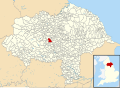 North Stainley with Sleningford UK parish locator map.svg 1,425 × 1,037; 4.3 MB
-
 Old Wheel - geograph.org.uk - 1234912.jpg 480 × 640; 160 KB
-
 Oliver's Stray - geograph.org.uk - 803040.jpg 640 × 427; 76 KB
-
 On Round Hill - geograph.org.uk - 3183197.jpg 4,320 × 3,240; 4.08 MB
-
 On the footpath between Ripon and North Lees - geograph.org.uk - 3182315.jpg 4,320 × 3,118; 4.65 MB
-
 Ordnance Survey cut benchmark - geograph.org.uk - 5401741.jpg 4,000 × 3,000; 2.72 MB
-
 Owl at Lightwater Valley - geograph.org.uk - 3049188.jpg 472 × 640; 191 KB
-
 Park Lane - geograph.org.uk - 5874680.jpg 4,288 × 2,848; 1.27 MB
-
 Park Lane at Sike Wood - geograph.org.uk - 5874739.jpg 2,848 × 4,288; 2.16 MB
-
 Path to North Lees - geograph.org.uk - 5816520.jpg 4,288 × 2,848; 2.55 MB
-
 Private nature reserve north of North Parks - geograph.org.uk - 3511668.jpg 1,632 × 1,224; 611 KB
-
 Private Road to Potgate Farm - geograph.org.uk - 2584293.jpg 640 × 427; 299 KB
-
 Red House Farm - geograph.org.uk - 643938.jpg 640 × 330; 42 KB
-
 Red House Farm - geograph.org.uk - 802991.jpg 640 × 427; 69 KB
-
 Ripon Loop Nature Reserve - geograph.org.uk - 5873850.jpg 4,288 × 2,848; 1.62 MB
-
 Ripon Loop Nature Reserve - geograph.org.uk - 5874151.jpg 4,288 × 2,848; 1.74 MB
-
 Ripon Loop Nature Reserve - geograph.org.uk - 5874394.jpg 4,288 × 2,848; 1.73 MB
-
 Ripon Rowel at North Parks Farm - geograph.org.uk - 3607848.jpg 4,320 × 3,240; 3.92 MB
-
 Ripon Rowel between North Parks and North Stainley - geograph.org.uk - 3607878.jpg 4,320 × 3,240; 4.26 MB
-
 Ripon Rowel heading towards North Stainley - geograph.org.uk - 3608033.jpg 4,320 × 3,240; 5.45 MB
-
 Ripon Rowel near North Parks Farm - geograph.org.uk - 3607865.jpg 4,320 × 3,240; 4.11 MB
-
 Ripon Rowel route into North Stainley - geograph.org.uk - 5878862.jpg 4,320 × 3,240; 4.35 MB
-
 Ripon Rowel south of South Parks Farm - geograph.org.uk - 3514111.jpg 1,632 × 1,224; 339 KB
-
 Ripon Rowel Walk at Spring Hill - geograph.org.uk - 5873343.jpg 4,288 × 2,848; 2.09 MB
-
 Ripon Rowel Walk east of North Stainley - geograph.org.uk - 3511647.jpg 1,632 × 1,224; 490 KB
-
 Ripon Rowel Walk on Park Lane - geograph.org.uk - 5874687.jpg 4,261 × 2,560; 1.29 MB
-
 River Ure - geograph.org.uk - 2456781.jpg 640 × 427; 286 KB
-
 River Ure - geograph.org.uk - 2456797.jpg 640 × 427; 264 KB
-
 River Ure - geograph.org.uk - 2456801.jpg 640 × 427; 285 KB
-
 River Ure - geograph.org.uk - 5926572.jpg 2,000 × 1,333; 2.59 MB
-
 River Ure at West Tanfield - geograph.org.uk - 4086244.jpg 1,024 × 768; 158 KB
-
 River Ure below West Tanfield - geograph.org.uk - 3608577.jpg 4,320 × 3,240; 3.18 MB
-
 River Ure between West Tanfield and Mickley - geograph.org.uk - 2930280.jpg 4,320 × 3,240; 4.75 MB
-

-
 River Ure from The Terrace - geograph.org.uk - 3511565.jpg 1,632 × 1,224; 474 KB
-
 River Ure looking Upstream from The Terrace - geograph.org.uk - 3608557.jpg 4,320 × 3,240; 5.78 MB
-
 River Ure southwest of Nunwick - geograph.org.uk - 5820667.jpg 2,848 × 4,288; 1.26 MB
-

-
 River Ure, Tanfield Bridge - geograph.org.uk - 4060091.jpg 640 × 484; 353 KB
-
 River Ure, West Tanfield - geograph.org.uk - 1935737.jpg 1,280 × 853; 414 KB
-
 River Ure, West Tanfield - geograph.org.uk - 5635901.jpg 4,000 × 3,000; 2.5 MB
-
 Road from Ripon Loop Nature Reserve - geograph.org.uk - 5874671.jpg 4,288 × 2,848; 2.58 MB
-
 Road into Ripon Loop Nature Reserve - geograph.org.uk - 5874641.jpg 4,288 × 2,848; 1.42 MB
-
 Road Junction A6108 - geograph.org.uk - 2584336.jpg 640 × 427; 226 KB
-
 Road junction at Musterfield - geograph.org.uk - 5911910.jpg 4,320 × 3,240; 2.61 MB
-
 Road to Ripon Loop Nature Reserve - geograph.org.uk - 5874684.jpg 4,248 × 2,538; 1.04 MB
-
 Rolling Countryside - geograph.org.uk - 815450.jpg 640 × 427; 59 KB
-
 Rotation Franco - geograph.org.uk - 4694133.jpg 1,600 × 1,065; 748 KB
-
 Rotation Franco - geograph.org.uk - 4694136.jpg 1,600 × 1,065; 272 KB
-
 Ruined Footbridge Across the Ure - geograph.org.uk - 2456775.jpg 640 × 427; 266 KB
-
 Rural aspect near North Lees - geograph.org.uk - 3182323.jpg 640 × 480; 59 KB
-
 School at North Stainley - geograph.org.uk - 3511568.jpg 1,632 × 1,224; 370 KB
-
 Sleningford Park gateway - geograph.org.uk - 5879353.jpg 3,576 × 2,110; 1.75 MB
-
 Sleningford Water Mill - geograph.org.uk - 3608569.jpg 4,320 × 3,240; 3.33 MB
-
 St. Mary the Virgin, North Stainley - geograph.org.uk - 4642377.jpg 1,024 × 768; 593 KB
-
 St. Mary's Court, North Stainley - geograph.org.uk - 3608069.jpg 4,141 × 3,216; 2.74 MB
-
 Stile on Footpath off New Road - geograph.org.uk - 2584323.jpg 640 × 427; 286 KB
-
 Straw House Farm - geograph.org.uk - 4862120.jpg 1,600 × 1,200; 445 KB
-
 Straw House Farm - geograph.org.uk - 803081.jpg 640 × 413; 57 KB
-
 Structures by Park Lane - geograph.org.uk - 5874729.jpg 4,288 × 2,848; 2.07 MB
-
 Swan boats at Lightwater Valley - geograph.org.uk - 3049217.jpg 480 × 640; 189 KB
-
 Tanefelt Barn - geograph.org.uk - 1239234.jpg 640 × 480; 96 KB
-
 Tanfield Bridge - geograph.org.uk - 3511558.jpg 1,632 × 1,224; 670 KB
-
 Tanfield Bridge - geograph.org.uk - 4060093.jpg 640 × 482; 367 KB
-
 The car park at the Staveley Arms - geograph.org.uk - 4693830.jpg 1,600 × 1,065; 952 KB
-
 The Conservatory, Lightwater Valley - geograph.org.uk - 4894517.jpg 1,024 × 682; 187 KB
-
 The Eagle's Claw, Lightwater Valley - geograph.org.uk - 3049147.jpg 556 × 640; 190 KB
-
 The lake at Lightwater Valley - geograph.org.uk - 3049194.jpg 640 × 480; 194 KB
-
 The River Ure, looking upstream from near Quarry Hill - geograph.org.uk - 2463392.jpg 1,600 × 1,200; 732 KB
-
 The Sike - geograph.org.uk - 1239230.jpg 640 × 480; 171 KB
-
 The Staveley Arms at North Stainley - geograph.org.uk - 3084768.jpg 640 × 443; 67 KB
-
 The Staveley Arms, North Stainley - geograph.org.uk - 4693816.jpg 1,600 × 1,065; 399 KB
-
 The Staveley Arms, North Stainley - geograph.org.uk - 4693822.jpg 1,600 × 1,065; 448 KB
-
 The Terrace, North Lees - geograph.org.uk - 5875848.jpg 4,288 × 2,848; 1.51 MB
-
 The Wave - geograph.org.uk - 1944237.jpg 1,600 × 1,200; 558 KB
-
 Towards North Lees - geograph.org.uk - 5875773.jpg 4,288 × 2,848; 2.28 MB
-
 Towards South Parks Farm - geograph.org.uk - 5820549.jpg 3,611 × 2,283; 987 KB
-
 Track by the Ure - geograph.org.uk - 5874376.jpg 2,848 × 4,288; 2.08 MB
-
 Track leading to Round Hill - geograph.org.uk - 3183178.jpg 4,320 × 3,240; 5.53 MB
-
 Track, Ripon Loop Nature Reserve - geograph.org.uk - 5874382.jpg 4,288 × 2,848; 2.25 MB
-
 Track, Ripon Loop Nature Reserve - geograph.org.uk - 5874386.jpg 4,288 × 2,848; 2.17 MB
-
 Trees, West Tanfield - geograph.org.uk - 4920477.jpg 640 × 480; 289 KB
-
 Ure Footpath - geograph.org.uk - 1235753.jpg 640 × 366; 87 KB
-
 Very fine water feature in North Stainley - geograph.org.uk - 3511619.jpg 1,632 × 1,224; 585 KB
-
 View across the River Ure - geograph.org.uk - 5926568.jpg 2,000 × 1,333; 3.06 MB
-

-
 Village pond, North Stainley - geograph.org.uk - 5878874.jpg 3,240 × 3,706; 3.37 MB
-
 Warning signs on the approach to the quarry access road - geograph.org.uk - 3511638.jpg 1,632 × 1,224; 619 KB
-
 Waterlogged Track to North Lees - geograph.org.uk - 3182348.jpg 4,320 × 3,240; 5.59 MB
-
 Weir east of Tanfield Bridge - geograph.org.uk - 3511562.jpg 1,632 × 1,224; 574 KB
-
 Well cover near Mickley - geograph.org.uk - 4920421.jpg 640 × 480; 218 KB
-
 Well done Hanson - geograph.org.uk - 3511658.jpg 1,632 × 1,224; 417 KB
-

-
 Wheat by Dancing Lane - geograph.org.uk - 5876099.jpg 4,288 × 2,848; 2.21 MB
-
 Wheat near Spring Hill School - geograph.org.uk - 5876366.jpg 4,288 × 2,848; 2.55 MB
-
 Wheat near Spring Hill School - geograph.org.uk - 5876375.jpg 4,288 × 2,848; 2.71 MB
-
 Wheat near Straw House Farm - geograph.org.uk - 5876364.jpg 4,288 × 2,848; 2.13 MB
-
 Potgate Quarry - geograph.org.uk - 186069.jpg 640 × 480; 71 KB


