Category:Nightingale Lodge
Jump to navigation
Jump to search
| Object location | | View all coordinates using: OpenStreetMap |
|---|
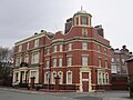
Originally built as a centre for District Nurses, later a hostel and as of 2017 is student apartments.
Media in category "Nightingale Lodge"
The following 10 files are in this category, out of 10 total.
-
 1 Princes Road, Nightingale Lodge-1.JPG 2,048 × 1,536; 450 KB
-
 1 Princes Road, Nightingale Lodge-2.JPG 1,830 × 1,482; 304 KB
-
 Nightingale Lodge 2017.jpg 3,909 × 3,328; 6.38 MB
-
 Nightingale Lodge, Liverpool (1).JPG 4,320 × 3,240; 3.02 MB
-
 Nightingale Lodge, Liverpool (2).JPG 4,320 × 3,240; 3.11 MB
-
 Nightingale Lodge, Liverpool (3).JPG 4,320 × 3,240; 3.09 MB
-
 Nightingale Lodge, Liverpool (4).JPG 4,320 × 3,240; 3.02 MB
-
 Nightingale Lodge, Liverpool (5).JPG 4,320 × 3,240; 2.98 MB
-
 Nightingale Lodge, Liverpool (6).JPG 4,320 × 3,240; 3.31 MB
-
 Princes Road, Liverpool (24).jpg 1,488 × 1,984; 576 KB


.JPG)
.JPG)
.JPG)
.JPG)
.JPG)
.JPG)
.jpg)