Category:Nieuwstad 32 (Hindeloopen)
Jump to navigation
Jump to search
| Object location | | View all coordinates using: OpenStreetMap |
|---|
 | |||||
| Upload media | |||||
| Instance of | |||||
|---|---|---|---|---|---|
| Location | Hindeloopen, Hindeloopen | ||||
| Located on street | |||||
| Heritage designation |
| ||||
 | |||||
|
This is a category about rijksmonument number 22187
|
| Address |
|
Media in category "Nieuwstad 32 (Hindeloopen)"
The following 12 files are in this category, out of 12 total.
-
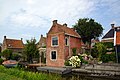 2018 Nieuwstad 32 Hindeloopen.jpg 2,000 × 1,333; 886 KB
-
 Achterhuis - Hindeloopen - 20113561 - RCE.jpg 1,200 × 804; 187 KB
-
 Achterkant litshuus - Hindeloopen - 20525087 - RCE.jpg 1,200 × 900; 122 KB
-
 Litshuus - Hindeloopen - 20525088 - RCE.jpg 1,200 × 900; 128 KB
-
 Nieuwstad32 Hindeloopen.jpg 2,736 × 3,648; 1.35 MB
-
 Tuin- of zomerhuisje - Hindeloopen - 20113592 - RCE.jpg 1,200 × 868; 285 KB
-
 Tuin- of zomerhuisje - Hindeloopen - 20113593 - RCE.jpg 1,200 × 872; 218 KB
-
 Tuin- of zomerhuisje - Hindeloopen - 20113594 - RCE.jpg 858 × 1,200; 266 KB
-
 Tuin- of zomerhuisje - Hindeloopen - 20113595 - RCE.jpg 866 × 1,200; 307 KB
-
 Tuin- of zomerhuisje - Hindeloopen - 20113596 - RCE.jpg 871 × 1,200; 201 KB
-
 Zomerhuisjes, woonhuizen - Hindeloopen - 20113597 - RCE.jpg 1,200 × 958; 310 KB
-
 Zomerhuisjes, woonhuizen - Hindeloopen - 20376694 - RCE.jpg 1,200 × 955; 284 KB


