Category:Nettelhorst
Jump to navigation
Jump to search
| Object location | | View all coordinates using: OpenStreetMap |
|---|
 | |||||
| Upload media | |||||
| Spoken text audio | |||||
|---|---|---|---|---|---|
| Instance of | |||||
| Location | Lochem, Gelderland, Netherlands | ||||
| Has part(s) | |||||
| Heritage designation |
| ||||
 | |||||
|
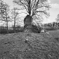
This is a category about rijksmonumentcomplex number 530926
|
Traptoren
|
This is a category about rijksmonument number 530927
|
Historische tuin- en parkaanleg
|
This is a category about rijksmonument number 530928
|
Schuur
|
This is a category about rijksmonument number 530930
|
| Address |
|
Media in category "Nettelhorst"
The following 21 files are in this category, out of 21 total.
-
 Exterieur OVERZICHT - Lochem - 20286256 - RCE.jpg 1,188 × 1,200; 432 KB
-
 Exterieur OVERZICHT - Lochem - 20286257 - RCE.jpg 1,191 × 1,200; 476 KB
-
 Exterieur OVERZICHT - Lochem - 20286258 - RCE.jpg 1,186 × 1,200; 466 KB
-
 Exterieur OVERZICHT - Lochem - 20286259 - RCE.jpg 1,198 × 1,200; 415 KB
-
 Exterieur OVERZICHT - Lochem - 20286260 - RCE.jpg 1,200 × 1,197; 526 KB
-
 Exterieur OVERZICHT RUINE - Lochem - 20339405 - RCE.jpg 1,197 × 1,200; 439 KB
-
 Exterieur OVERZICHT RUINE - Lochem - 20339406 - RCE.jpg 1,200 × 1,195; 391 KB
-
 Exterieur OVERZICHT RUINE - Lochem - 20339407 - RCE.jpg 1,188 × 1,200; 482 KB
-
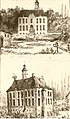
 Het Huis Nettelhorst, bij Lochem, RP-T-1921-225.jpg 5,382 × 2,932; 1.9 MB
-

-

-

-
 Nettelhorst wapen.svg 444 × 604; 53 KB
-
 Nettelhorst-zijkant.jpg 2,098 × 1,420; 534 KB
-
 Nettelhorst.jpg 500 × 851; 302 KB
-
 Reproductie van foto 1870 - Laren - 20129073 - RCE.jpg 1,056 × 767; 168 KB
-
 Reproductie van foto 1870 - Laren - 20129074 - RCE.jpg 777 × 970; 174 KB
-
 Reproductie van tekening door J.de Beyer - Laren - 20129075 - RCE.jpg 1,016 × 757; 184 KB
-
 Ruïne - Laren - 20129070 - RCE.jpg 1,200 × 791; 164 KB
-

-
 Walraven van Heeckeren (1570-1645).jpg 464 × 616; 48 KB


,_RP-P-OB-85.325.jpg)


.jpg)