Category:Nederlands Hervormde Kerk (Nunspeet)
Jump to navigation
Jump to search
| Object location | | View all coordinates using: OpenStreetMap |
|---|
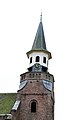
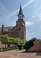
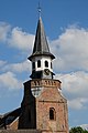
Nederlands: Afbeeldingen van de Nederlands Hervormde Kerk Nunspeet, Dorpsstraat 12, 8071 BZ Nunspeet. Gelegen in Nunspeet in de provincie Gelderland in Nederland.
Kerk
|
This is a category about a municipal monument in Nunspeet with number WN005 |
Toren
|
This is a category about rijksmonument number 30837
|
 | |||||
| Upload media | |||||
| Instance of |
| ||||
|---|---|---|---|---|---|
| Location | Nunspeet, Gelderland, Netherlands | ||||
| Street address |
| ||||
| Heritage designation |
| ||||
 | |||||
Subcategories
This category has only the following subcategory.
Media in category "Nederlands Hervormde Kerk (Nunspeet)"
The following 24 files are in this category, out of 24 total.
-
 Exterieur - Nunspeet - 20170350 - RCE.jpg 1,191 × 1,200; 259 KB
-
 Gezien vanuit het noord-westen - Nunspeet - 20170355 - RCE.jpg 1,200 × 960; 290 KB
-
 Nederlands Hervormde Kerk (Nunspeet) P1370995.jpg 4,000 × 2,672; 5.88 MB
-
 Nederlands Hervormde kerk en toren 2.jpg 4,496 × 3,000; 2.75 MB
-
 Nederlands Hervormde kerk en toren 3.jpg 3,000 × 4,496; 1.67 MB
-
 Nederlands Hervormde kerk en toren 4.jpg 4,496 × 3,000; 3.76 MB
-
 Nederlands Hervormde kerk en toren.jpg 3,113 × 2,998; 2.34 MB
-
 Noordgevel - Nunspeet - 20170353 - RCE.jpg 1,200 × 953; 221 KB
-
 Noordgevel - Nunspeet - 20170354 - RCE.jpg 1,200 × 951; 285 KB
-
 Noordgevel toren - Nunspeet - 20170352 - RCE.jpg 960 × 1,200; 303 KB
-
 Nunspeet 01562.JPG 500 × 281; 144 KB
-
 Nunspeet 2.jpg 1,136 × 848; 842 KB
-
 Nunspeet, de Nederlands Hervormde kerk GM0302WN005 IMG 4313 2018-06-27 13.45.jpg 3,507 × 5,008; 10.93 MB
-
 Nunspeet, de Nederlands Hervormde kerk RM30837 foto5 2013-07-15 14.08.jpg 3,312 × 4,416; 7.98 MB
-
 Toren Nederlands Hervormde Kerk (Nunspeet) P1370996.jpg 2,672 × 4,000; 5.83 MB
-
 Toren Nederlands Hervormde Kerk (Nunspeet) P1370997.jpg 2,672 × 4,000; 5.72 MB
-
 Toren Nederlands Hervormde Kerk (Nunspeet) P1370999.jpg 2,672 × 4,000; 5.72 MB
-
 Toren, exterieur - Nunspeet - 20170351 - RCE.jpg 1,200 × 1,200; 238 KB
-
 Tower detail of tthe Protestant church of Nunspeet - panoramio.jpg 2,848 × 4,288; 2.97 MB
-
 Zicht op Nunspeet1.jpg 3,648 × 2,736; 1.1 MB
-
 Zicht op Nunspeet2.jpg 3,648 × 2,736; 915 KB
-
 Zuid-oost gevel - Nunspeet - 20170356 - RCE.jpg 1,200 × 937; 291 KB
-
 Zuid-west zijde - Nunspeet - 20170357 - RCE.jpg 1,200 × 960; 239 KB
-
 Zuidgevel - Nunspeet - 20170358 - RCE.jpg 960 × 1,200; 315 KB


_P1370995.jpg)


_P1370996.jpg)
_P1370997.jpg)
_P1370999.jpg)


