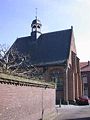
Category:Nederlands Hervormde Kerk, Ravenstein
Jump to navigation
Jump to search
| Object location | | View all coordinates using: OpenStreetMap |
|---|
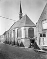
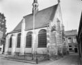
church building in Oss, Netherlands  | |||||
| Upload media | |||||
| Instance of | |||||
|---|---|---|---|---|---|
| Location | Ravenstein, Oss, North Brabant, Netherlands | ||||
| Street address |
| ||||
| Located on street |
| ||||
| Heritage designation |
| ||||
| Inception |
| ||||
| Significant event |
| ||||
 | |||||
Nederlands: Garnizoenskerk Ravenstein - anno 1641
|
This is a category about rijksmonument number 32365
|
| Address |
|
Subcategories
This category has only the following subcategory.
I
Media in category "Nederlands Hervormde Kerk, Ravenstein"
The following 60 files are in this category, out of 60 total.
-
 5371 Ravenstein, Netherlands - panoramio (33).jpg 4,896 × 2,760; 4.76 MB
-
 Dominee Hanewinkelplaats - Ravenstein - 20184708 - RCE.jpg 1,200 × 816; 241 KB
-
 Dominee Hanewinkelplaats - Ravenstein - 20184709 - RCE.jpg 1,200 × 823; 316 KB
-
 Exterieur naar het noord-westen - Ravenstein - 20184656 - RCE.jpg 960 × 1,200; 233 KB
-
 Exterieur naar het zuid-oosten - Ravenstein - 20184657 - RCE.jpg 1,200 × 962; 244 KB
-
 Exterieur voorgevel - Ravenstein - 20184672 - RCE.jpg 1,195 × 1,200; 423 KB
-
 Exterieur voorgevel - Ravenstein - 20184673 - RCE.jpg 1,200 × 1,200; 388 KB
-
 Exterieur voorgevel - Ravenstein - 20184674 - RCE.jpg 1,200 × 1,184; 462 KB
-
 Exterieur voorgevel - Ravenstein - 20184675 - RCE.jpg 1,193 × 1,200; 426 KB
-
 Exterieur voorgevel - Ravenstein - 20184676 - RCE.jpg 1,200 × 1,195; 420 KB
-
 Exterieur voorgevel - Ravenstein - 20184677 - RCE.jpg 1,200 × 1,200; 424 KB
-
 Exterieur voorgevel - Ravenstein - 20184678 - RCE.jpg 1,200 × 1,200; 392 KB
-
 Exterieur voorgevel - Ravenstein - 20184679 - RCE.jpg 1,200 × 1,188; 399 KB
-
 Exterieur voorgevel - Ravenstein - 20184680 - RCE.jpg 1,200 × 1,197; 415 KB
-
 Exterieur voorgevel - Ravenstein - 20184681 - RCE.jpg 1,200 × 1,200; 359 KB
-
 Exterieur voorgevel - Ravenstein - 20184682 - RCE.jpg 1,200 × 1,191; 339 KB
-
 Exterieur west-gevel - Ravenstein - 20184670 - RCE.jpg 960 × 1,200; 233 KB
-
 Exterieur west-zijde - Ravenstein - 20184667 - RCE.jpg 1,200 × 950; 176 KB
-
 Exterieur zuid-gevel - Ravenstein - 20184668 - RCE.jpg 960 × 1,200; 259 KB
-
 Exterieur zuid-oost zijde - Ravenstein - 20184669 - RCE.jpg 1,200 × 955; 255 KB
-
 Garnizoenskerk Ravenstein 10.jpg 4,032 × 2,268; 4.96 MB
-
 Garnizoenskerk Ravenstein 11.jpg 3,968 × 3,552; 8.69 MB
-
 Garnizoenskerk Ravenstein 2.jpg 2,268 × 4,032; 3.63 MB
-
 Garnizoenskerk Ravenstein 3.jpg 4,032 × 2,268; 6.21 MB
-
 Garnizoenskerk Ravenstein 4.jpg 3,968 × 3,472; 9.42 MB
-
 Garnizoenskerk Ravenstein 5.jpg 2,268 × 4,032; 5.24 MB
-
 Garnizoenskerk Ravenstein 6.jpg 3,984 × 3,936; 11.84 MB
-
 Garnizoenskerk Ravenstein 7.jpg 4,032 × 2,268; 4.68 MB
-
 Garnizoenskerk Ravenstein 8.jpg 4,032 × 2,268; 4.05 MB
-
 Garnizoenskerk Ravenstein 9.jpg 4,032 × 2,268; 3.48 MB
-
 Garnizoenskerk Ravenstein achteringang.jpg 4,470 × 3,353; 12.66 MB
-
 Garnizoenskerk Ravenstein deur zijkant.jpg 3,885 × 2,696; 7.11 MB
-
 Garnizoenskerk Ravenstein deur.jpg 4,103 × 2,831; 6.68 MB
-
 Garnizoenskerk Ravenstein gevelsteen.jpg 4,465 × 3,349; 11.54 MB
-
 Garnizoenskerk Ravenstein infobord.jpg 5,184 × 3,456; 12.83 MB
-
 Garnizoenskerk Ravenstein informatiebord.jpg 4,192 × 2,896; 8.74 MB
-
 Garnizoenskerk Ravenstein ingang.jpg 4,609 × 3,339; 10.95 MB
-
 Garnizoenskerk Ravenstein Latijnse inscriptie.jpg 3,892 × 3,072; 8.64 MB
-
 Garnizoenskerk Ravenstein naambord.jpg 3,886 × 2,729; 8.48 MB
-
 Garnizoenskerk Ravenstein naamplaatje.jpg 3,188 × 2,579; 5.87 MB
-
 Garnizoenskerk Ravenstein schuin achter links.jpg 3,788 × 2,949; 6.87 MB
-
 Garnizoenskerk Ravenstein schuin links voor.jpg 5,068 × 3,384; 13.42 MB
-
 Garnizoenskerk Ravenstein schuin links.jpg 3,940 × 2,770; 7.63 MB
-
 Garnizoenskerk Ravenstein schuin rechts achter.jpg 4,592 × 3,444; 13.21 MB
-
 Garnizoenskerk Ravenstein schuin rechts voor.jpg 4,376 × 3,282; 6.56 MB
-
 Garnizoenskerk Ravenstein voorkant totaal.jpg 3,810 × 2,735; 6.34 MB
-
 Garnizoenskerk Ravenstein voorkant winterdag.jpg 4,907 × 3,364; 12.09 MB
-
 Garnizoenskerk Ravenstein.jpg 4,032 × 2,268; 4.75 MB
-
 Montand - Ravenstein - 20184661 - RCE.jpg 877 × 1,200; 140 KB
-
 Montand - Ravenstein - 20184662 - RCE.jpg 1,200 × 874; 171 KB
-
 Montand - Ravenstein - 20184663 - RCE.jpg 874 × 1,200; 196 KB
-
 Montand - Ravenstein - 20184664 - RCE.jpg 871 × 1,200; 172 KB
-
 Montand - Ravenstein - 20184665 - RCE.jpg 1,200 × 873; 166 KB
-
 Montand - Ravenstein - 20184666 - RCE.jpg 873 × 1,200; 143 KB
-
 Ravenstein - Servetstraat 1.jpg 1,944 × 2,592; 1.4 MB
-
 Ravensteingarnizoenskerk.jpg 300 × 400; 15 KB
-
 Toegangsdeur binnenzijde - Ravenstein - 20184688 - RCE.jpg 809 × 1,200; 282 KB
-
 Toegangsdeur buitendijde - Ravenstein - 20184687 - RCE.jpg 788 × 1,200; 252 KB
-
 Voorgevel, ingangspartij - Ravenstein - 20184671 - RCE.jpg 1,193 × 1,200; 400 KB
-
 Westgevel - Ravenstein - 20184697 - RCE.jpg 807 × 1,200; 204 KB
.jpg)


