Category:Nederlands Hervormde Kerk, Moordrecht
Jump to navigation
Jump to search
| Object location | | View all coordinates using: OpenStreetMap |
|---|
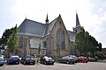
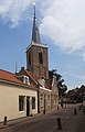
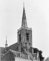
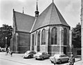
church building in Zuidplas, Netherlands  | |||||
| Upload media | |||||
| Instance of | |||||
|---|---|---|---|---|---|
| Location | Moordrecht, South Holland, Netherlands | ||||
| Street address |
| ||||
| Located on street |
| ||||
| Heritage designation |
| ||||
 | |||||
Nederlands: Nederlands Hervormde Kerk, Moordrecht
Kerk:
|
This is a category about rijksmonument number 30093
|
Toren:
|
This is a category about rijksmonument number 30094
|
| Address |
|
Subcategories
This category has only the following subcategory.
Media in category "Nederlands Hervormde Kerk, Moordrecht"
The following 15 files are in this category, out of 15 total.
-
 Moordrecht 05.JPG 4,288 × 2,848; 3.08 MB
-
-
 Moordrecht.JPG 2,848 × 4,288; 3.05 MB
-
 Noord-west zijde - Moordrecht - 20160817 - RCE.jpg 942 × 1,200; 173 KB
-

-
 Overzicht zuidgevel met transept - Moordrecht - 20366633 - RCE.jpg 1,200 × 926; 226 KB
-
 RM30093 - Moordrecht - Kerkplein 12.jpg 3,264 × 2,448; 2.16 MB
-
 RM30094 - Moordrecht - Kerkplein 12 (ingang).jpg 3,264 × 2,448; 2.62 MB
-
 RM30094 - Moordrecht - Kerkplein 12.jpg 2,448 × 3,264; 1.38 MB
-
 Toren naar het noorden - Moordrecht - 20160807 - RCE.jpg 951 × 1,200; 225 KB
-
 Toren zuid-west zijde - Moordrecht - 20160816 - RCE.jpg 946 × 1,200; 306 KB
-
 Torenspits naar het zuid-oosten - Moordrecht - 20160808 - RCE.jpg 959 × 1,200; 141 KB
-
 Torenvoet naar het zuid-oosten - Moordrecht - 20160809 - RCE.jpg 941 × 1,200; 266 KB
-
 Zuid-oost zijde - Moordrecht - 20160818 - RCE.jpg 1,200 × 936; 282 KB
-
 Zuid-transept - Moordrecht - 20160819 - RCE.jpg 1,200 × 1,019; 268 KB


.jpg)


