Category:Nederlands Hervormde Kerk, Burgh
Jump to navigation
Jump to search
| Object location | | View all coordinates using: OpenStreetMap |
|---|
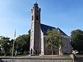
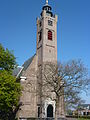
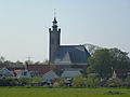
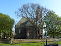
church building in Schouwen-Duiveland, Netherlands  | |||||
| Upload media | |||||
| Instance of | |||||
|---|---|---|---|---|---|
| Location | Burgh-Haamstede, Schouwen-Duiveland, Zeeland, Netherlands | ||||
| Street address |
| ||||
| Heritage designation |
| ||||
| Inception |
| ||||
 | |||||
Nederlands: Hervormde Kerk, Burgh - anno 1671
Kerk
|
This is a category about rijksmonument number 38779
|
Toren
|
This is a category about rijksmonument number 38778
|
| Address |
|
Subcategories
This category has the following 4 subcategories, out of 4 total.
E
- Epitaaf van David de Huybert (5 F)
- Epitaaf van Johannes de Huybert (24 F)
- Epitaaf van Pieter de Huybert (126 F)
Media in category "Nederlands Hervormde Kerk, Burgh"
The following 32 files are in this category, out of 32 total.
-
 Beschilderd venster oost muur, epitafen en koorbank - Burgh - 20045956 - RCE.jpg 1,200 × 901; 170 KB
-
 BURGH HERVORMDE KERK.jpg 4,608 × 3,456; 3.17 MB
-
 Burghsering 33, Burgh (2).JPG 3,240 × 4,320; 5 MB
-
 Burghsering 33, Burgh (3).JPG 4,320 × 3,240; 5.28 MB
-
 Burghsering 33, Burgh - deur.JPG 3,240 × 4,320; 4.86 MB
-
 Burghsering 33, Burgh - toren detail.JPG 3,240 × 4,320; 5.04 MB
-
 Burghsering 33, Burgh - toren.JPG 3,240 × 4,320; 5.04 MB
-
 Burghsering 33, Burgh.JPG 4,320 × 3,240; 5.53 MB
-
 Deel grafmonument tijdens restauratie - Burg - 20323346 - RCE.jpg 907 × 1,200; 173 KB
-
 Exterieur - Burgh - 20045954 - RCE.jpg 959 × 1,200; 222 KB
-
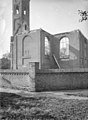
 Exterieur na de brand, naar het noord-oosten - Burgh - 20045948 - RCE.jpg 881 × 1,200; 228 KB
-
 Exterieur na de brand, naar het noord-westen - Burgh - 20045949 - RCE.jpg 880 × 1,200; 247 KB
-
 Exterieur na de brand, naar het noord-westen - Burgh - 20045950 - RCE.jpg 883 × 1,200; 227 KB
-
 Exterieur na de brand, naar het oosten - Burgh - 20045952 - RCE.jpg 881 × 1,200; 286 KB
-
 Exterieur na de brand, naar het zuid-oosten - Burgh - 20045951 - RCE.jpg 890 × 1,200; 272 KB
-

-
 Ingang toren, na de brand - Burgh - 20045953 - RCE.jpg 904 × 1,200; 266 KB
-
 Ingangspartij van de toren - Burgh - 20045964 - RCE.jpg 894 × 1,200; 245 KB
-
 Interieur - Burgh - 20045965 - RCE.jpg 1,200 × 960; 174 KB
-
 Interieur - Burgh - 20045966 - RCE.jpg 1,200 × 960; 185 KB
-
 Interieur naar het orgel - Burgh - 20045967 - RCE.jpg 956 × 1,200; 195 KB
-
 Interieur naar het zuid-oosten, na de brand - Burgh - 20045955 - RCE.jpg 1,200 × 881; 214 KB
-
 Interieur, aanzicht orgel, orgelnummer 257 - Burgh - 20358295 - RCE.jpg 809 × 1,200; 143 KB
-

-
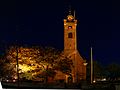 Kirche Burgh Nachts.jpg 4,608 × 3,464; 26.45 MB
-
 Noordgevel - Burgh - 20045969 - RCE.jpg 1,200 × 955; 367 KB
-
 Noordgevel - Burgh - 20045970 - RCE.jpg 1,200 × 957; 368 KB
-
 Overzicht hervormde kerk zuidzijde - Burgh - 20319145 - RCE.jpg 898 × 1,200; 180 KB
-
 Overzicht zuidwestgevel met kerktoren - Burgh - 20352300 - RCE.jpg 950 × 1,200; 215 KB
-

-
 Speeltafel orgel - Burgh - 20045968 - RCE.jpg 959 × 1,200; 179 KB
-
 Uitwendig, kerk - Burgh - 20045963 - RCE.jpg 959 × 1,200; 233 KB


.JPG)
.JPG)


