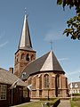
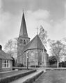
Category:Nederlands Hervormde Kerk, Borne
Jump to navigation
Jump to search
| Object location | | View all coordinates using: OpenStreetMap |
|---|
church building in Borne, Netherlands  | |||||
| Upload media | |||||
| Instance of | |||||
|---|---|---|---|---|---|
| Location | Borne, Overijssel, Netherlands | ||||
| Street address |
| ||||
| Located on street |
| ||||
| Heritage designation |
| ||||
 | |||||
Nederlands: StephanusKerk - anno 15e eeuw
Kerk
|
This is a category about rijksmonument number 9929
|
Toren
|
This is a category about rijksmonument number 9930
|
| Address |
|
Subcategories
This category has only the following subcategory.
I
- Interior of Oude Kerk, Borne (36 F)
Media in category "Nederlands Hervormde Kerk, Borne"
The following 20 files are in this category, out of 20 total.
-
 2006-07-15 12.44 Borne, kerk 2 foto2.JPG 1,704 × 2,272; 2.29 MB
-
 Borne Oude Kerk w.jpg 1,952 × 2,576; 3.17 MB
-
 Exterieur - Borne - 20038415 - RCE.jpg 813 × 1,200; 217 KB
-
 Exterieur naar het noord-westen - Borne - 20038382 - RCE.jpg 932 × 1,200; 201 KB
-
 Exterieur naar het noord-westen - Borne - 20038387 - RCE.jpg 1,200 × 959; 285 KB
-
 Exterieur naar het zuid-westen - Borne - 20038383 - RCE.jpg 885 × 1,200; 199 KB
-
 Exterieur naar het zuid-westen - Borne - 20038384 - RCE.jpg 886 × 1,200; 213 KB
-
 Exterieur naar het zuid-westen - Borne - 20038385 - RCE.jpg 878 × 1,200; 227 KB
-
 Exterieur naar het zuiden - Borne - 20038381 - RCE.jpg 888 × 1,200; 174 KB
-
 Exterieur vanui het oost noord-oosten - Borne - 20038378 - RCE.jpg 866 × 1,200; 229 KB
-
 Exterieur vanuit het zuid zuid-westen - Borne - 20038377 - RCE.jpg 872 × 1,200; 187 KB
-
 Exterieur vanuit het zuid-oosten - Borne - 20038380 - RCE.jpg 860 × 1,200; 228 KB
-
 Exterieur vanuit het zuid-zuiden - Borne - 20038379 - RCE.jpg 1,200 × 868; 222 KB
-
 Hoek Potkampstraat - Borne - 20038545 - RCE.jpg 1,200 × 810; 236 KB
-
 Ingang Toren west zijde - Borne - 20038386 - RCE.jpg 884 × 1,200; 279 KB
-
 Muurschildering noord schip naar het oosten - Borne - 20038404 - RCE.jpg 889 × 1,200; 225 KB
-
 Nederlands Hervormde Kerk church Borne 2019 2.jpg 4,928 × 3,264; 6.41 MB
-
 Nederlands Hervormde Kerk church Borne 2019.jpg 3,264 × 4,928; 6.56 MB
-
 Oude Kerk Borne.jpg 1,952 × 2,576; 1.16 MB
-
 Overzicht zuidoostgevel met kerktoren - Borne - 20351568 - RCE.jpg 947 × 1,200; 260 KB


